IMAGES TAKEN NEAR TO
KIRRIEMUIR, DD8 5LY
Introduction
This page details the photographs taken nearby to DD8 5LY by members of the Geograph project.
The Geograph project started in 2005 with the aim of publishing, organising and preserving representative images for every square kilometre of Great Britain, Ireland and the Isle of Man.

There are currently over 7.5m images from over14,400 individuals and you can help contribute to the project by visiting https://www.geograph.org.uk
Image Map
Images are licensed for reuse under creativecommons.org/licenses/by-sa/2.0
Notes
- Clicking on the map will re-center to the selected point.
- The higher the marker number, the further away the image location is from the centre of the postcode.
Image Listing (6 Images Found)
Images are licensed for reuse under creativecommons.org/licenses/by-sa/2.0
Image
Details
Distance
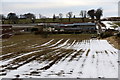
2
Kinalty overlooking Strathmore
To the Sidlaw Hills, Kinpurney Hill with its tower visible on the left.
Image: © Russel Wills
Taken: 7 Apr 2016
0.03 miles
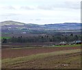
3
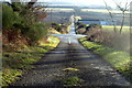
View of Kinalty Farm and Road
The photo was taken from the Roundyhill Road near its junction with the Lendrick Lodge / Logie Road. The road climbing past the farm joins with the Kirriemuir / Blairgowrie Road.
Image: © Alan Morrison
Taken: 13 Jan 2009
0.06 miles
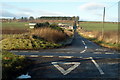
5
Lindertis Home Farm Road at its junction with Kirriemuir / Blairgowrie Road
The road leads straight ahead to Kinalty Farm, culminating at the Logie / Lendrick House and Roundyhill roads.
Image: © Alan Morrison
Taken: 13 Jan 2009
0.21 miles
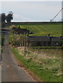
6
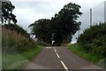
Kinalty Road at its junction with Blairgowrie / Kirriemuir Road
Image: © Alan Morrison
Taken: 11 Sep 2008
0.24 miles