IMAGES TAKEN NEAR TO
Main Road, KIRRIEMUIR, DD8 5LP
Introduction
This page details the photographs taken nearby to Main Road, DD8 5LP by members of the Geograph project.
The Geograph project started in 2005 with the aim of publishing, organising and preserving representative images for every square kilometre of Great Britain, Ireland and the Isle of Man.

There are currently over 7.5m images from over14,400 individuals and you can help contribute to the project by visiting https://www.geograph.org.uk
Image Map
Images are licensed for reuse under creativecommons.org/licenses/by-sa/2.0
Notes
- Clicking on the map will re-center to the selected point.
- The higher the marker number, the further away the image location is from the centre of the postcode.
Image Listing (5 Images Found)
Images are licensed for reuse under creativecommons.org/licenses/by-sa/2.0
Image
Details
Distance
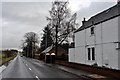
2
Footpath signs, Westmuir
A signs indicate routes on the Kirriemuir Footpath Network.
Image: © Maigheach-gheal
Taken: 6 Oct 2009
0.09 miles
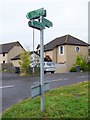
3
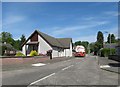
Village scene, Westmuir
Westmuir is a village divided by the A926. The image shows the shop-cum-post office and a K6 type telephone box.
Image: © Maigheach-gheal
Taken: 6 Oct 2009
0.12 miles
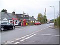
4
Westmuir Shoppie Post Office
Surely the centre of the Universe!
Image: © Gwen and James Anderson
Taken: 3 Feb 2006
0.16 miles
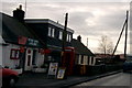
5
Old School Road in Westmuir.
Looks like someone is getting their fuel supply topped up.
Image: © James Denham
Taken: 3 Jun 2010
0.18 miles