IMAGES TAKEN NEAR TO
KIRRIEMUIR, DD8 5JT
Introduction
This page details the photographs taken nearby to DD8 5JT by members of the Geograph project.
The Geograph project started in 2005 with the aim of publishing, organising and preserving representative images for every square kilometre of Great Britain, Ireland and the Isle of Man.

There are currently over 7.5m images from over14,400 individuals and you can help contribute to the project by visiting https://www.geograph.org.uk
Image Map
Images are licensed for reuse under creativecommons.org/licenses/by-sa/2.0
Notes
- Clicking on the map will re-center to the selected point.
- The higher the marker number, the further away the image location is from the centre of the postcode.
Image Listing (10 Images Found)
Images are licensed for reuse under creativecommons.org/licenses/by-sa/2.0
Image
Details
Distance
1
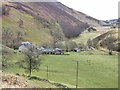
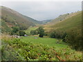
Auldallan and the valley of the Quharity Burn
This valley which runs along the foot of the Highlands to the north (left) gives the strong impression of having been a glacial overflow channel dating from the Ice Age.
Image: © Oliver Dixon
Taken: 20 Mar 2012
0.02 miles
2

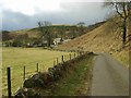
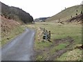
Minor road at Auldallan
Looking eastward.
Image: © Peter Wood
Taken: 27 Jun 2019
0.02 miles
3
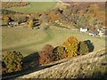
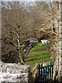
Auldallan
Collection of buildings and steading conversions. A view from under the colourful beeches can be seen here Image
Image: © Richard Webb
Taken: 4 Nov 2007
0.03 miles
4
Looking down on Auldallan
Auldallan viewed from high up on the road to the west.
Image: © Scott Cormie
Taken: 28 Jul 2020
0.03 miles
5
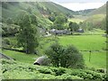
Auldallan
Looking down on the former farm, now steading conversions of Auldallan.
Image: © Richard Webb
Taken: 4 Nov 2007
0.03 miles
8
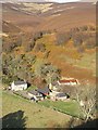
View from above Audallan
This is interesting scenery. A steep sided valley with a small burn and flat floor. The valley runs along the base of the higher hills rather than away from them and gives one the impression that this must have been some sort of glacial meltwater channel.
Image: © Gordon Hatton
Taken: 14 Sep 2021
0.09 miles
9
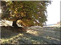
Beeches, Auldallan
A line of beech trees opposite Auldallan.
Image: © Richard Webb
Taken: 4 Nov 2007
0.09 miles
10
The "High Road" at Auldallan
The valley of the Quharity Burn which runs along the foot of the Highlands to the north (left) gives the strong impression of having been a glacial overflow channel dating from the Ice Age.
Image: © Oliver Dixon
Taken: 20 Mar 2012
0.10 miles