IMAGES TAKEN NEAR TO
Lintrathen, KIRRIEMUIR, DD8 5JQ
Introduction
This page details the photographs taken nearby to DD8 5JQ by members of the Geograph project.
The Geograph project started in 2005 with the aim of publishing, organising and preserving representative images for every square kilometre of Great Britain, Ireland and the Isle of Man.

There are currently over 7.5m images from over14,400 individuals and you can help contribute to the project by visiting https://www.geograph.org.uk
Image Map
Images are licensed for reuse under creativecommons.org/licenses/by-sa/2.0
Notes
- Clicking on the map will re-center to the selected point.
- The higher the marker number, the further away the image location is from the centre of the postcode.
Image Listing (9 Images Found)
Images are licensed for reuse under creativecommons.org/licenses/by-sa/2.0
Image
Details
Distance

5

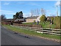
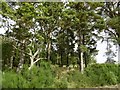
Valley of the Melgam
The tree-lined Melgam Water from the B951 near Pitmudie, with Torrax beyond.
Image: © Scott Cormie
Taken: 30 Jul 2017
0.19 miles
6
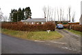
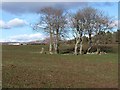
Pitmudie
Fields amongst the woodlands near Loch of Lintrathen.
Image: © Richard Webb
Taken: 16 Sep 2015
0.19 miles
8
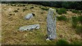
Pitmudie stone row
Only one of the original three stones remains standing (Scale 1m). https://stonerows.wordpress.com/gazetteer/region/central-scotland/pitmudie/
Image: © Sandy Gerrard
Taken: 3 Dec 2016
0.22 miles
9
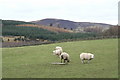
Clump of trees near Inzion
Cairn Plew Image can be seen on the skyline.
Image: © Oliver Dixon
Taken: 17 Mar 2012
0.23 miles