IMAGES TAKEN NEAR TO
Lintrathen, KIRRIEMUIR, DD8 5HZ
Introduction
This page details the photographs taken nearby to DD8 5HZ by members of the Geograph project.
The Geograph project started in 2005 with the aim of publishing, organising and preserving representative images for every square kilometre of Great Britain, Ireland and the Isle of Man.

There are currently over 7.5m images from over14,400 individuals and you can help contribute to the project by visiting https://www.geograph.org.uk
Image Map
Images are licensed for reuse under creativecommons.org/licenses/by-sa/2.0
Notes
- Clicking on the map will re-center to the selected point.
- The higher the marker number, the further away the image location is from the centre of the postcode.
Image Listing (5 Images Found)
Images are licensed for reuse under creativecommons.org/licenses/by-sa/2.0
Image
Details
Distance
1
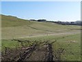
The slopes of Brankam Hill
Open grassland beside the B951.
Image: © Oliver Dixon
Taken: 17 Mar 2012
0.13 miles
2

B951 at Purgavie
The B951 heading eastwards from the top of the hill at Purgavie.
Image: © Scott Cormie
Taken: 30 Jul 2017
0.13 miles
3
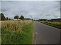
B951 passes Roadside Cottage
Kirriemuir to Glenisla road.
Image: © Richard Webb
Taken: 16 Sep 2015
0.15 miles
4
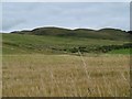
North of the road, Purgavie
Looking towards Welton Hill.
Image: © Richard Webb
Taken: 16 Sep 2015
0.17 miles
5
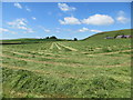
Hay making time near Wardend - drying after cutting
Looking westward.
Image: © Peter Wood
Taken: 26 Jun 2019
0.24 miles