IMAGES TAKEN NEAR TO
Kingoldrum, KIRRIEMUIR, DD8 5HB
Introduction
This page details the photographs taken nearby to DD8 5HB by members of the Geograph project.
The Geograph project started in 2005 with the aim of publishing, organising and preserving representative images for every square kilometre of Great Britain, Ireland and the Isle of Man.

There are currently over 7.5m images from over14,400 individuals and you can help contribute to the project by visiting https://www.geograph.org.uk
Image Map
Images are licensed for reuse under creativecommons.org/licenses/by-sa/2.0
Notes
- Clicking on the map will re-center to the selected point.
- The higher the marker number, the further away the image location is from the centre of the postcode.
Image Listing (6 Images Found)
Images are licensed for reuse under creativecommons.org/licenses/by-sa/2.0
Image
Details
Distance
2
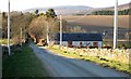
Aucharroch Road
Looking up the Aucharroch farm road with a farm cottage on the right. The western flank of The Crandard is on the right and slopes leading to Cat Law lie beyond.
Image: © Robert Bone
Taken: 1 Apr 2007
0.05 miles
3
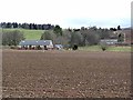
Aucharroch Farm
Taken looking north from near Kingoldrum village. The farm cottages lie some distance to right of the farmhouse and steading. Ascreavie wood and the eastern flank of Cat Law are in the distance.
Image: © Robert Bone
Taken: 11 Aug 2003
0.12 miles
4
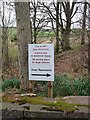
Peevish notice
Fed up with the sat navs getting it wrong.
Image: © Oliver Dixon
Taken: 20 Mar 2012
0.17 miles
5
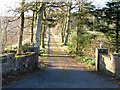
Ascreavie House Road
Photograph taken looking up the drive to Ascreavie House. This was onetime home to plant hunter Major George Sheriff. His last expedition, with colleague Frank Ludlow, was to Bhutan in 1949 and yielded a total of 5,000 species.
Image: © Robert Bone
Taken: 1 Apr 2007
0.18 miles
6
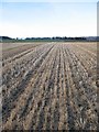
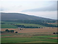
Aucharroch
A stubble field with grassland higher up.
Image: © Richard Webb
Taken: 4 Nov 2007
0.22 miles