IMAGES TAKEN NEAR TO
Kingoldrum, KIRRIEMUIR, DD8 5HA
Introduction
This page details the photographs taken nearby to DD8 5HA by members of the Geograph project.
The Geograph project started in 2005 with the aim of publishing, organising and preserving representative images for every square kilometre of Great Britain, Ireland and the Isle of Man.

There are currently over 7.5m images from over14,400 individuals and you can help contribute to the project by visiting https://www.geograph.org.uk
Image Map
Images are licensed for reuse under creativecommons.org/licenses/by-sa/2.0
Notes
- Clicking on the map will re-center to the selected point.
- The higher the marker number, the further away the image location is from the centre of the postcode.
Image Listing (5 Images Found)
Images are licensed for reuse under creativecommons.org/licenses/by-sa/2.0
Image
Details
Distance
1
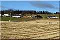
Over Ascreavie Farm
The photo was taken from the Aucharroch / Over Ascreavie Road.
Image: © Alan Morrison
Taken: 13 Jan 2009
0.05 miles
2
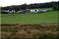
Ascreavie, near Kirkton of Kingoldrum
Image: © Mike Pennington
Taken: 10 Aug 2009
0.07 miles
3

Grazing cattle near a marshy pond
Off a minor road between Pearsie and Barnton, The houses in the background are in the hamlet of Over Ascreavie.
Image: © Stanley Howe
Taken: 28 Jul 2016
0.19 miles
4
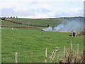
Fire at Over Ascreavie
Burning taking place near the entrance to Over Ascreavie farm.
Image: © Scott Cormie
Taken: 22 Oct 2017
0.21 miles
5
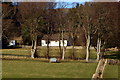
Dwelling House at Ascreavie
The horse is very patient (bottom right)
Image: © Alan Morrison
Taken: 13 Jan 2009
0.24 miles