IMAGES TAKEN NEAR TO
Kingoldrum, KIRRIEMUIR, DD8 5EZ
Introduction
This page details the photographs taken nearby to DD8 5EZ by members of the Geograph project.
The Geograph project started in 2005 with the aim of publishing, organising and preserving representative images for every square kilometre of Great Britain, Ireland and the Isle of Man.

There are currently over 7.5m images from over14,400 individuals and you can help contribute to the project by visiting https://www.geograph.org.uk
Image Map
Images are licensed for reuse under creativecommons.org/licenses/by-sa/2.0
Notes
- Clicking on the map will re-center to the selected point.
- The higher the marker number, the further away the image location is from the centre of the postcode.
Image Listing (3 Images Found)
Images are licensed for reuse under creativecommons.org/licenses/by-sa/2.0
Image
Details
Distance
1
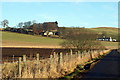
Nether Ascreavie Farm
Nether Ascreavie Farm Cottages can also be clearly seen.
Image: © Alan Morrison
Taken: 13 Jan 2009
0.07 miles
2
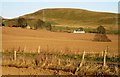
Nether Ascreavie
The farmstead of Nether Ascreavie basking in evening light with Culhawk Hill (310 mAOD) beyond.
Image: © Robert Bone
Taken: 1 Apr 2007
0.09 miles
3
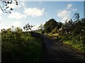
After the storm
A May storm had felled many trees. The remains of one lie to the right after road was cleared.
Image: © Douglas Nelson
Taken: 24 May 2011
0.15 miles