IMAGES TAKEN NEAR TO
KIRRIEMUIR, DD8 5EX
Introduction
This page details the photographs taken nearby to DD8 5EX by members of the Geograph project.
The Geograph project started in 2005 with the aim of publishing, organising and preserving representative images for every square kilometre of Great Britain, Ireland and the Isle of Man.

There are currently over 7.5m images from over14,400 individuals and you can help contribute to the project by visiting https://www.geograph.org.uk
Image Map
Images are licensed for reuse under creativecommons.org/licenses/by-sa/2.0
Notes
- Clicking on the map will re-center to the selected point.
- The higher the marker number, the further away the image location is from the centre of the postcode.
Image Listing (3 Images Found)
Images are licensed for reuse under creativecommons.org/licenses/by-sa/2.0
Image
Details
Distance
1
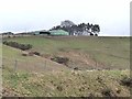
Upper Balgray
Farm standing at the top of a steep bluff rising from the valley of the Quharity Burn.
Image: © Oliver Dixon
Taken: 20 Mar 2012
0.03 miles
3
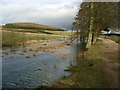
Flooding at Upper Balgray
The nearby lochan has extended into the small row of trees beside the track.
Image: © Gordon Brown
Taken: 10 Mar 2007
0.12 miles