IMAGES TAKEN NEAR TO
Pearsie, KIRRIEMUIR, DD8 4RP
Introduction
This page details the photographs taken nearby to DD8 4RP by members of the Geograph project.
The Geograph project started in 2005 with the aim of publishing, organising and preserving representative images for every square kilometre of Great Britain, Ireland and the Isle of Man.

There are currently over 7.5m images from over14,400 individuals and you can help contribute to the project by visiting https://www.geograph.org.uk
Image Map
Images are licensed for reuse under creativecommons.org/licenses/by-sa/2.0
Notes
- Clicking on the map will re-center to the selected point.
- The higher the marker number, the further away the image location is from the centre of the postcode.
Image Listing (6 Images Found)
Images are licensed for reuse under creativecommons.org/licenses/by-sa/2.0
Image
Details
Distance
1
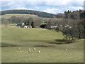
Pearsie
Cluster of houses in Glen Prosen.
Image: © Oliver Dixon
Taken: 18 Mar 2012
0.06 miles
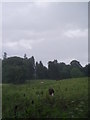
3
Driveway to the Pearsie Estate
In Glen Prosen.
Image: © Oliver Dixon
Taken: 18 Mar 2012
0.23 miles

5
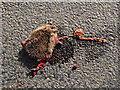
Roadkill near Pearsie.
A hedgehog - one of an estimated five million wild animals killed on Britain's roads each year. A relatively short cycle ride through Glen Prosen in April 2011 revealed extensive roadkill, including deer, rabbit, pheasant, hedgehog and one polecat. The Geograph website is to be archived by the British Library - it is interesting to speculate what future generations will make of this carnage.
Image: © William Starkey
Taken: 17 Apr 2011
0.24 miles
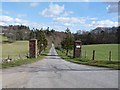
6
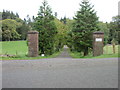
Pearsie Entrance
The entrance to Pearsie House from the west.
Image: © Scott Cormie
Taken: 2 Oct 2017
0.25 miles