IMAGES TAKEN NEAR TO
Kinnordy, KIRRIEMUIR, DD8 4RG
Introduction
This page details the photographs taken nearby to DD8 4RG by members of the Geograph project.
The Geograph project started in 2005 with the aim of publishing, organising and preserving representative images for every square kilometre of Great Britain, Ireland and the Isle of Man.

There are currently over 7.5m images from over14,400 individuals and you can help contribute to the project by visiting https://www.geograph.org.uk
Image Map
Images are licensed for reuse under creativecommons.org/licenses/by-sa/2.0
Notes
- Clicking on the map will re-center to the selected point.
- The higher the marker number, the further away the image location is from the centre of the postcode.
Image Listing (11 Images Found)
Images are licensed for reuse under creativecommons.org/licenses/by-sa/2.0
Image
Details
Distance
1
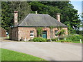
Kinnordy Estate Office
At Causewayend, near Kirriemuir.
Image: © M J Richardson
Taken: 31 Jul 2012
0.00 miles
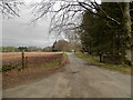
2
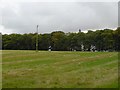
Kirriemuir / Meams Road at Caddam Junction
The road ahead leads to Kinnordy Home Farm
Image: © Alan Morrison
Taken: 2 Jan 2009
0.04 miles
3
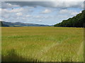
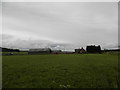
Barley at Kinnordy
Looking northeast along the road to Caddam Wood towards the lower parts of Glen Clova and Glen Prosen.
Image: © M J Richardson
Taken: 31 Jul 2012
0.07 miles
5
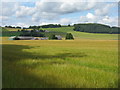
Barley at East Inch
Looking north to woodland on Mearns Hill.
Image: © M J Richardson
Taken: 31 Jul 2012
0.17 miles
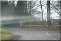
7
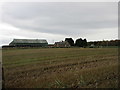
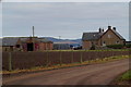
East Inch Farm
East Inch from the minor road to the west.
Image: © Scott Cormie
Taken: 22 Oct 2017
0.21 miles