IMAGES TAKEN NEAR TO
Glenclova, KIRRIEMUIR, DD8 4QU
Introduction
This page details the photographs taken nearby to DD8 4QU by members of the Geograph project.
The Geograph project started in 2005 with the aim of publishing, organising and preserving representative images for every square kilometre of Great Britain, Ireland and the Isle of Man.

There are currently over 7.5m images from over14,400 individuals and you can help contribute to the project by visiting https://www.geograph.org.uk
Image Map
Images are licensed for reuse under creativecommons.org/licenses/by-sa/2.0
Notes
- Clicking on the map will re-center to the selected point.
- The higher the marker number, the further away the image location is from the centre of the postcode.
Image Listing (7 Images Found)
Images are licensed for reuse under creativecommons.org/licenses/by-sa/2.0
Image
Details
Distance
1
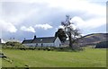
Clachnabrain
Overlooking the River South Esk.
Image: © Russel Wills
Taken: 6 Apr 2016
0.02 miles
2
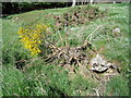
The last surviving twig
The broom bush is almost dead - but not yet!
I took this photo opposite the Clach na Brain Farmhouse near Gella Bridge, Glen Clova
Image: © Astrid H
Taken: 4 Jul 2009
0.03 miles
3
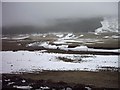
Glen Clova
The River South Esk flows through Glen Clova in The Cairngorms National Park. This photo was taken from the side of the B955 on the east side of the river.
Image: © Jennie Hodson
Taken: 7 Mar 2006
0.12 miles
4
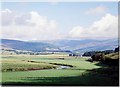
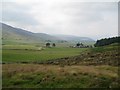
Glen Clova
For much of its middle reaches, Glen Clova has a wide flat floor indicating a former glacial lake bed. This photo taken from Clachnabrain on the eastern loop of the B955.
Image: © Gordon Hatton
Taken: Unknown
0.13 miles
5
Glen Clova
Looking up the glen from a track above Gella.
Image: © Lis Burke
Taken: 26 Jul 2008
0.13 miles
6
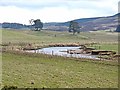
Meander on the River South Esk
In Glen Clova. The Airlie Memorial Tower Image can be seen on the skyline.
Image: © Oliver Dixon
Taken: 19 Mar 2012
0.17 miles
7
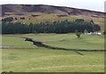
River South Esk
With Clachnabrain on the other bank below The Aud.
Image: © Russel Wills
Taken: 6 Apr 2016
0.20 miles