IMAGES TAKEN NEAR TO
KIRRIEMUIR, DD8 4QP
Introduction
This page details the photographs taken nearby to DD8 4QP by members of the Geograph project.
The Geograph project started in 2005 with the aim of publishing, organising and preserving representative images for every square kilometre of Great Britain, Ireland and the Isle of Man.

There are currently over 7.5m images from over14,400 individuals and you can help contribute to the project by visiting https://www.geograph.org.uk
Image Map
Images are licensed for reuse under creativecommons.org/licenses/by-sa/2.0
Notes
- Clicking on the map will re-center to the selected point.
- The higher the marker number, the further away the image location is from the centre of the postcode.
Image Listing (8 Images Found)
Images are licensed for reuse under creativecommons.org/licenses/by-sa/2.0
Image
Details
Distance
1
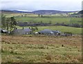
Crossbog
With Kinrive beyond on the left.
Farms near the mouth of Glen Clova.
Image: © Russel Wills
Taken: 6 Apr 2016
0.02 miles
2
Crossbog
The farm is picturesquely situated just downhill from the road in Glen Clova. It seems to have been the only view to attract the eyes of Geograph submitters, as there are already two similar views: Image] and Image
Image: © Anne Burgess
Taken: 2 Mar 2010
0.02 miles
3
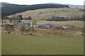
Crossbog Farm, lower Glen Clova.
Image: © Gwen and James Anderson
Taken: 26 Feb 2006
0.04 miles
4
Crossbog Farm, Glen Clova, Angus
This photograph was taken from the Kirriemuir / Glen Clova Road, Angus, looking in the direction of Kinrive, Glen Moy.
Image: © Alan Morrison
Taken: 12 Oct 2007
0.04 miles
5
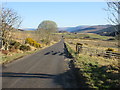
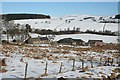
B955 in lower Glen Clova
The B955 heading northwards into Glen Clova, with the Craigs of Loch Wharrel on the horizon straight ahead.
Image: © Scott Cormie
Taken: 21 Apr 2020
0.09 miles
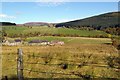
6
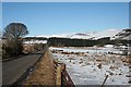
Lower Glen Clova
This is the B955 road which goes up the length of Glen Clova and into Glen Doll. The craggy cliffs on the hilltop in line with the road are the ones round Loch Brandy, and the nearest summit on the skyline is Finbracks (756 metres).
Image: © Anne Burgess
Taken: 2 Mar 2010
0.12 miles
7
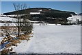
Looking towards Benscravie
Although the foreground and middle ground here are in square, the eye is irresistibly drawn along the line of the old drystane dyke to the summit of forest-clad Benscravie (428 metres) on the far side of the glen.
Image: © Anne Burgess
Taken: 2 Mar 2010
0.15 miles
8
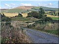
Farm drive to Crosmiln Farm
Some moraine=like hillocks in the foreground. Benscravie Image on the skyline.
Image: © Oliver Dixon
Taken: 29 Sep 2024
0.21 miles