IMAGES TAKEN NEAR TO
Cortachy, KIRRIEMUIR, DD8 4QG
Introduction
This page details the photographs taken nearby to DD8 4QG by members of the Geograph project.
The Geograph project started in 2005 with the aim of publishing, organising and preserving representative images for every square kilometre of Great Britain, Ireland and the Isle of Man.

There are currently over 7.5m images from over14,400 individuals and you can help contribute to the project by visiting https://www.geograph.org.uk
Image Map
Images are licensed for reuse under creativecommons.org/licenses/by-sa/2.0
Notes
- Clicking on the map will re-center to the selected point.
- The higher the marker number, the further away the image location is from the centre of the postcode.
Image Listing (7 Images Found)
Images are licensed for reuse under creativecommons.org/licenses/by-sa/2.0
Image
Details
Distance
1
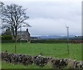
Muirhouses
With its antiquated twin bladed wind turbine.
Image: © Russel Wills
Taken: 6 Apr 2016
0.01 miles
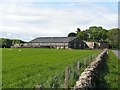
5
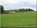
Muirhouses Farm Cottages
Seen across the fields.
Image: © Richard Webb
Taken: 19 May 2007
0.13 miles
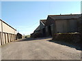
6
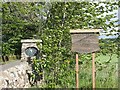
Auchlishie road end
Signs at the end of the drive.
Image: © Richard Webb
Taken: 19 May 2007
0.18 miles
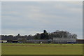
7
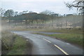
Kirriemuir / Cortachy junction approaching from Crieff Farm
Image: © Alan Morrison
Taken: 2 Jan 2009
0.20 miles