IMAGES TAKEN NEAR TO
Northmuir, KIRRIEMUIR, DD8 4PE
Introduction
This page details the photographs taken nearby to DD8 4PE by members of the Geograph project.
The Geograph project started in 2005 with the aim of publishing, organising and preserving representative images for every square kilometre of Great Britain, Ireland and the Isle of Man.

There are currently over 7.5m images from over14,400 individuals and you can help contribute to the project by visiting https://www.geograph.org.uk
Image Map
Images are licensed for reuse under creativecommons.org/licenses/by-sa/2.0
Notes
- Clicking on the map will re-center to the selected point.
- The higher the marker number, the further away the image location is from the centre of the postcode.
Image Listing (4 Images Found)
Images are licensed for reuse under creativecommons.org/licenses/by-sa/2.0
Image
Details
Distance
1
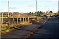
Cortachy Road, Kirriemuir at its junction with Mid Road
The green signpost to the left depicts a route for Kirriemuir Path Network.
Image: © Alan Morrison
Taken: 13 Jan 2009
0.12 miles
3
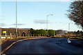
Cortachy Road, Kirriemuir at its junction with Windyghoul Road and Angle Road
Image: © Alan Morrison
Taken: 13 Jan 2009
0.16 miles
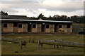
4
Road leading to Woodside
Woodside House can be clearly seen and nestles at the edge of Caddam Wood.
Image: © Alan Morrison
Taken: 13 Jan 2009
0.23 miles