IMAGES TAKEN NEAR TO
KIRRIEMUIR, DD8 4PB
Introduction
This page details the photographs taken nearby to DD8 4PB by members of the Geograph project.
The Geograph project started in 2005 with the aim of publishing, organising and preserving representative images for every square kilometre of Great Britain, Ireland and the Isle of Man.

There are currently over 7.5m images from over14,400 individuals and you can help contribute to the project by visiting https://www.geograph.org.uk
Image Map
Images are licensed for reuse under creativecommons.org/licenses/by-sa/2.0
Notes
- Clicking on the map will re-center to the selected point.
- The higher the marker number, the further away the image location is from the centre of the postcode.
Image Listing (4 Images Found)
Images are licensed for reuse under creativecommons.org/licenses/by-sa/2.0
Image
Details
Distance
1
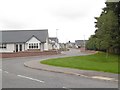
Lord Lyell Drive
New houses in Kirriemuir.
Image: © Richard Webb
Taken: 16 Sep 2015
0.15 miles
2
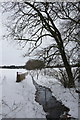
Burn between Kirriemuir and Kinnordy
Image: © Mike Pennington
Taken: 26 Dec 2010
0.19 miles
3
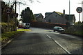
Road Junction of B956 and B951
Photograph taken on approach from the road leading to Meams Farm.
Image: © Alan Morrison
Taken: 13 Jan 2009
0.19 miles
4
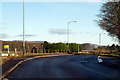
Cortachy Road, Kirriemuir at its junction with Windyghoul Road and Angle Road
Image: © Alan Morrison
Taken: 13 Jan 2009
0.23 miles