IMAGES TAKEN NEAR TO
Kinnordy, KIRRIEMUIR, DD8 4LS
Introduction
This page details the photographs taken nearby to DD8 4LS by members of the Geograph project.
The Geograph project started in 2005 with the aim of publishing, organising and preserving representative images for every square kilometre of Great Britain, Ireland and the Isle of Man.

There are currently over 7.5m images from over14,400 individuals and you can help contribute to the project by visiting https://www.geograph.org.uk
Image Map
Images are licensed for reuse under creativecommons.org/licenses/by-sa/2.0
Notes
- Clicking on the map will re-center to the selected point.
- The higher the marker number, the further away the image location is from the centre of the postcode.
Image Listing (5 Images Found)
Images are licensed for reuse under creativecommons.org/licenses/by-sa/2.0
Image
Details
Distance
1
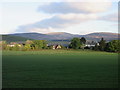
Auchlishie from the south-east
Looking north-westwards to Auchlishie from the B955, with Catlaw in the background.
Image: © Scott Cormie
Taken: 11 May 2020
0.03 miles
3
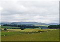
Farmland at Auchlishie
Mixed farming near Auchlishie, with both grazing and arable land visible in this image. Hills surrounding Glen Prosen can be seen in the distance.
Image: © William Starkey
Taken: 26 Jul 2012
0.11 miles
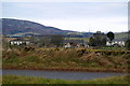
4
Startled Geese in a field near Auchlishie, Kirriemuir
Auchlishie farm is not too clear, but that is the direction the photograph was taken from the Kirriemuir / Cortachy Road
Image: © Alan Morrison
Taken: 4 Jan 2008
0.12 miles
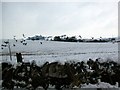
5
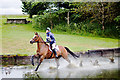
Water jump
A horse and rider in the water jump on the cross country course at Auchlishie, near Kirriemuir.
Image: © William Starkey
Taken: 26 Jul 2012
0.16 miles