IMAGES TAKEN NEAR TO
Kinnordy, KIRRIEMUIR, DD8 4LG
Introduction
This page details the photographs taken nearby to DD8 4LG by members of the Geograph project.
The Geograph project started in 2005 with the aim of publishing, organising and preserving representative images for every square kilometre of Great Britain, Ireland and the Isle of Man.

There are currently over 7.5m images from over14,400 individuals and you can help contribute to the project by visiting https://www.geograph.org.uk
Image Map
Images are licensed for reuse under creativecommons.org/licenses/by-sa/2.0
Notes
- Clicking on the map will re-center to the selected point.
- The higher the marker number, the further away the image location is from the centre of the postcode.
Image Listing (7 Images Found)
Images are licensed for reuse under creativecommons.org/licenses/by-sa/2.0
Image
Details
Distance
1
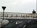
Road Junction near Kirriemuir
This is a view of the Kirriemuir/Oathlaw/Glasswell junction.
Image: © Alan Morrison
Taken: 4 Jan 2008
0.04 miles
4
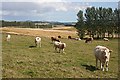
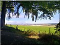
Strathmore
A view from the eastern outskirts of Kirriemuir across Strathmore. Lombardy poplars, neither native nor all that common here, have been planted to fringe and shelter the fields, which are used for mixed arable and livestock. In the distance are Turin Hill and Finavon Hill.
Image: © Anne Burgess
Taken: 30 Jul 2009
0.18 miles
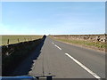
5
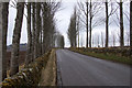
Lombardy poplars along the road to Glasswell, Kirriemuir
Image: © Mike Pennington
Taken: 12 Apr 2013
0.20 miles
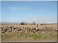
6
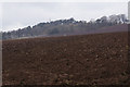
Ploughed field east of Kirriemuir
Looking towards the Hill of Kirriemuir
Image: © Mike Pennington
Taken: 12 Apr 2013
0.21 miles
7
View from the hill
The eastern view from Kirriemuir Hill is not the one that is commonly photographed.
Image: © Aleks Scholz
Taken: 1 Sep 2022
0.23 miles