1
Old church and churchyard
The Kirriemuir Barony parish churchyard has a number of 17th century monuments and is listed, category C(S) with details at: http://www.britishlistedbuildings.co.uk/sc-36811-kirriemuir-barony-parish-churchyard-high-#.V5b4YTU5t8E
The church, built in 1788, is listed, category B with details at: http://www.britishlistedbuildings.co.uk/sc-36810-kirriemuir-barony-parish-church-high-stre#.V5b5XzU5t8E
The hall was added in 1904.
Image: © Michael Dibb
Taken: 18 Jun 2016
0.02 miles
2
Church and hall
The Kirriemuir Barony parish churchyard has a number of 17th century monuments and is listed, category C(S) with details at: http://www.britishlistedbuildings.co.uk/sc-36811-kirriemuir-barony-parish-churchyard-high-#.V5b4YTU5t8E
The church, built in 1788, is listed, category B with details at: http://www.britishlistedbuildings.co.uk/sc-36810-kirriemuir-barony-parish-church-high-stre#.V5b5XzU5t8E
The hall was added in 1904.
Image: © Michael Dibb
Taken: 18 Jun 2016
0.02 miles
3
Date stone
Seen above a doorway in Kirk Wynd. The stone is obviously not from 1688.
Image: © Michael Dibb
Taken: 18 Jun 2016
0.02 miles
4
The way to the (old) church
This alleyway runs from Bank Street to the former parish church.
Image: © Michael Dibb
Taken: 18 Jun 2016
0.03 miles
5
Parish church
The church, built in 1788, is listed, category B with details at: http://www.britishlistedbuildings.co.uk/sc-36810-kirriemuir-barony-parish-church-high-stre#.V5b5XzU5t8E
Image: © Michael Dibb
Taken: 18 Jun 2016
0.03 miles
6
Arch in Manse Close, Kirriemuir
Image: © Gwen and James Anderson
Taken: 28 Jun 2007
0.03 miles
7
88 Degrees, Kirriemuir
This award winning café and deli, has hand made chocolates and cakes. As well as artisan cheese, home grown salad and a generally delicious menu.
Image: © Gwen and James Anderson
Taken: 17 Apr 2008
0.03 miles
8
Kirriemuir Old Parish Church
Ninth-century stones were found when the church was rebuilt on this earlier Christian site in 1788 to a design by James Playfair, father of William Henry Playfair. The steeple was completed in 1790.
https://www.scotlandschurchestrust.org.uk/church/kirriemuir-old-parish-church
Image: © Russel Wills
Taken: 5 Apr 2016
0.03 miles
9
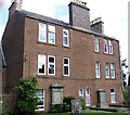
Backing onto the churchyard
This property with a large number of chimneys directly backs onto the churchyard of the Kirriemuir Barony parish church. The building is listed, category C(S) with details at: http://www.britishlistedbuildings.co.uk/sc-36850-30-34-bank-street-#.V5b75DU5t8E
Image: © Michael Dibb
Taken: 18 Jun 2016
0.03 miles
10
A bridge to Bridges
Bridges is the name of the coffee house. The bridge carries foot traffic over Kirk Wynd. Notice the pre-Worboys sign. The building accommodating Bridges is listed, category C(S) with details at: http://www.britishlistedbuildings.co.uk/sc-36852-42-44-bank-street-#.V5hD7TU5t8E For a reverse view see
Image
Image: © Michael Dibb
Taken: 18 Jun 2016
0.04 miles


