IMAGES TAKEN NEAR TO
Tannadice, FORFAR, DD8 3SN
Introduction
This page details the photographs taken nearby to DD8 3SN by members of the Geograph project.
The Geograph project started in 2005 with the aim of publishing, organising and preserving representative images for every square kilometre of Great Britain, Ireland and the Isle of Man.

There are currently over 7.5m images from over14,400 individuals and you can help contribute to the project by visiting https://www.geograph.org.uk
Image Map
Images are licensed for reuse under creativecommons.org/licenses/by-sa/2.0
Notes
- Clicking on the map will re-center to the selected point.
- The higher the marker number, the further away the image location is from the centre of the postcode.
Image Listing (8 Images Found)
Images are licensed for reuse under creativecommons.org/licenses/by-sa/2.0
Image
Details
Distance
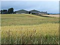
1

Field of barley at Baldoukie Farm
Cloud hangs low over the Highlands in the background.
Image: © Oliver Dixon
Taken: 9 Aug 2013
0.11 miles
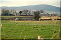
2
Barley field near Meikle Coull
Meikle Coull farm Image stands on the hill beyond.
Image: © Oliver Dixon
Taken: 9 Aug 2013
0.13 miles
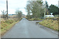
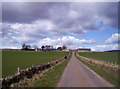
4
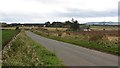
Baldoukie
A minor road amongst scattered dwellings.
Image: © Richard Webb
Taken: 9 Oct 2011
0.16 miles
5
Meikle Coull Farm
Image: © Dominic Dawn Harry and Jacob Paterson
Taken: 14 Apr 2006
0.19 miles
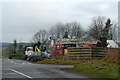
7
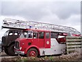
Fire Engine
Beside a workshop a very unlikely scene amongst fields.
Image: © Gwen and James Anderson
Taken: 28 Jun 2007
0.23 miles