IMAGES TAKEN NEAR TO
FORFAR, DD8 3PG
Introduction
This page details the photographs taken nearby to DD8 3PG by members of the Geograph project.
The Geograph project started in 2005 with the aim of publishing, organising and preserving representative images for every square kilometre of Great Britain, Ireland and the Isle of Man.

There are currently over 7.5m images from over14,400 individuals and you can help contribute to the project by visiting https://www.geograph.org.uk
Image Map
Images are licensed for reuse under creativecommons.org/licenses/by-sa/2.0
Notes
- Clicking on the map will re-center to the selected point.
- The higher the marker number, the further away the image location is from the centre of the postcode.
Image Listing (12 Images Found)
Images are licensed for reuse under creativecommons.org/licenses/by-sa/2.0
Image
Details
Distance
1
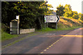
Bogindollo Road End Bus Stop on the A90
Image: © David Dixon
Taken: 24 Sep 2018
0.03 miles
2
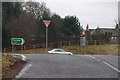
Justinhaugh Road at its junction with the A90 at Parkford
Image: © Alan Morrison
Taken: 14 Jan 2009
0.03 miles
3

Aftermath of Potato harvesting at west side of Parkford / Bogindollo road
This crop of potatoes was lifted by machines. The line of trees to the right of the picture shows the course of the Lemno Burn.
Image: © Alan Morrison
Taken: 14 Jan 2009
0.18 miles
4
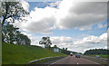
Approaching the Oathlaw turnoff
Photographer is above the southbound travel lanes of A90.
Image: © C Michael Hogan
Taken: 10 Jun 2011
0.19 miles
5
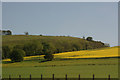
Trees along burn at Parkford, north of Forfar
Image: © Mike Pennington
Taken: 3 Jun 2011
0.19 miles
6
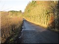
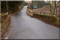
Road to Bogindollo
The minor road heading down the hill from the A90 towards Bogindollo.
Image: © Scott Cormie
Taken: 31 Dec 2019
0.19 miles
7
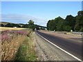
A90 near Parkford
The A90 dual-carriageway on the southbound side approaching the Bogindollo turn off.
Image: © Scott Cormie
Taken: 8 Jul 2018
0.21 miles
9
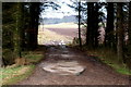
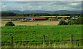
Avenue into Farmland east of the Bridge at Bogindollo
The avenue is through a strip of trees to the east side of Bogindollo / Parkford road. Looking beyond the avenue ploughed fields can be seen and it is reasonable to believe that the tree line seen on the extreme right at the far end of the picture forms part of Clatterha' Strip.
Image: © Alan Morrison
Taken: 14 Jan 2009
0.21 miles
10
Bridge over the Lemno Burn near Bogindollo
The Lemno Burn eventually joins the River South Esk at Finavon. This is somewhat strange as Aberlemno is some miles upstream from here. I was of the opinion that 'Aber' meant 'river mouth'. Perhaps at one time Aberlemno was at Finavon!
Image: © Alan Morrison
Taken: 14 Jan 2009
0.23 miles