IMAGES TAKEN NEAR TO
FORFAR, DD8 3PB
Introduction
This page details the photographs taken nearby to DD8 3PB by members of the Geograph project.
The Geograph project started in 2005 with the aim of publishing, organising and preserving representative images for every square kilometre of Great Britain, Ireland and the Isle of Man.

There are currently over 7.5m images from over14,400 individuals and you can help contribute to the project by visiting https://www.geograph.org.uk
Image Map
Images are licensed for reuse under creativecommons.org/licenses/by-sa/2.0
Notes
- Clicking on the map will re-center to the selected point.
- The higher the marker number, the further away the image location is from the centre of the postcode.
Image Listing (6 Images Found)
Images are licensed for reuse under creativecommons.org/licenses/by-sa/2.0
Image
Details
Distance
1

Back of Turin Hill.
There is a group of houses and farmsteads, collectively marked on the Map as 'Back of Turin Hill'. The farmland is split into small fields, all individually fenced, holding a variety of crops, grazing and livestock.
Image: © Gwen and James Anderson
Taken: 15 May 2007
0.08 miles
2
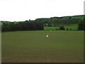
Young crop field with scarecrows, Carsegowniemuir
Image: © JThomas
Taken: 11 Jun 2021
0.09 miles
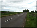
4

Back of Turin Hill
My on ascent must have been from the front.
Image: © Richard Webb
Taken: 23 Jan 2016
0.20 miles
5
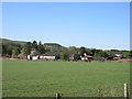
Farm buildings at Fordmouth
Looking south-westwards to outbuildings at Fordmouth.
Image: © Scott Cormie
Taken: 7 May 2020
0.22 miles
6
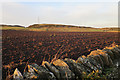
Drystane Dyke and Ploughed Land
The foreground is in square but Finavon Hill, on the skyline, is in the next square
Image: © Anne Burgess
Taken: 25 Jan 2018
0.23 miles