IMAGES TAKEN NEAR TO
FORFAR, DD8 3PA
Introduction
This page details the photographs taken nearby to DD8 3PA by members of the Geograph project.
The Geograph project started in 2005 with the aim of publishing, organising and preserving representative images for every square kilometre of Great Britain, Ireland and the Isle of Man.

There are currently over 7.5m images from over14,400 individuals and you can help contribute to the project by visiting https://www.geograph.org.uk
Image Map
Images are licensed for reuse under creativecommons.org/licenses/by-sa/2.0
Notes
- Clicking on the map will re-center to the selected point.
- The higher the marker number, the further away the image location is from the centre of the postcode.
Image Listing (4 Images Found)
Images are licensed for reuse under creativecommons.org/licenses/by-sa/2.0
Image
Details
Distance
2
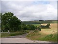
B9134 approaching Howmuir Farm Cottages
Towards Brechin.
Image: © JThomas
Taken: 11 Jun 2021
0.20 miles
3
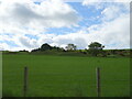
Grazing near Pitscandly New House
Looking towards old quarry workings.
Image: © JThomas
Taken: 11 Jun 2021
0.24 miles