IMAGES TAKEN NEAR TO
FORFAR, DD8 3NN
Introduction
This page details the photographs taken nearby to DD8 3NN by members of the Geograph project.
The Geograph project started in 2005 with the aim of publishing, organising and preserving representative images for every square kilometre of Great Britain, Ireland and the Isle of Man.

There are currently over 7.5m images from over14,400 individuals and you can help contribute to the project by visiting https://www.geograph.org.uk
Image Map
Images are licensed for reuse under creativecommons.org/licenses/by-sa/2.0
Notes
- Clicking on the map will re-center to the selected point.
- The higher the marker number, the further away the image location is from the centre of the postcode.
Image Listing (6 Images Found)
Images are licensed for reuse under creativecommons.org/licenses/by-sa/2.0
Image
Details
Distance
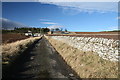
1
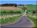
View of Baggerton Farm, near Forfar
Taken from the road near Carseburn.
Image: © Alan Morrison
Taken: 28 Apr 2007
0.05 miles
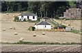
3
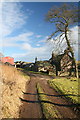
Baggerton Farm
A mixed livestock / arable farm.
Image: © Dan
Taken: 21 Feb 2009
0.06 miles
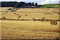
6
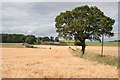
Baggerton
Barley fields by the burn slope upwards towards the steading and cottages at Baggerton. The gridline passes through the farm.
Image: © Anne Burgess
Taken: 8 Aug 2007
0.23 miles