IMAGES TAKEN NEAR TO
Carseview Road, FORFAR, DD8 3BT
Introduction
This page details the photographs taken nearby to Carseview Road, DD8 3BT by members of the Geograph project.
The Geograph project started in 2005 with the aim of publishing, organising and preserving representative images for every square kilometre of Great Britain, Ireland and the Isle of Man.

There are currently over 7.5m images from over14,400 individuals and you can help contribute to the project by visiting https://www.geograph.org.uk
Image Map
Images are licensed for reuse under creativecommons.org/licenses/by-sa/2.0
Notes
- Clicking on the map will re-center to the selected point.
- The higher the marker number, the further away the image location is from the centre of the postcode.
Image Listing (25 Images Found)
Images are licensed for reuse under creativecommons.org/licenses/by-sa/2.0
Image
Details
Distance
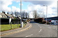
1
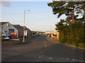
Carseview Road
Carseview Road on the north-eastern outskirts of Forfar. A mainly industrial street seen from the junction of Suttieside Road.
Image: © Scott Cormie
Taken: 20 Aug 2017
0.05 miles
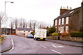
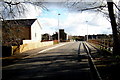
2
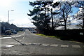
Carseview Road, Forfar, looking southwest
Picture taken from its junction with Suttieside Road.
Image: © Alan Morrison
Taken: 4 Mar 2009
0.05 miles
3
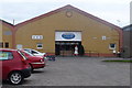
Frostys Funhouse, Forfar
Bravely described as 'Forfar's first ice-themed children's soft play area' the facility is based near the Forfar ice rink, hence the name and theme. The absence of any apostrophe is consistent on all the company's signage and literature!
Image: © Mike Pennington
Taken: 1 Apr 2009
0.09 miles
4
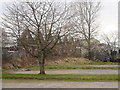
Former Forfar railway station
The area is now an industrial estate.
Image: © Mike Pennington
Taken: 1 Apr 2009
0.10 miles
5
Suttieside Road, Forfar
Picture taken from its junction with Carseview Road.
Image: © Alan Morrison
Taken: 4 Mar 2009
0.12 miles
6
Suttieside Road, Forfar
Photo taken from its junction with Station Road.
Image: © Alan Morrison
Taken: 16 Feb 2009
0.12 miles
7
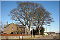
View of Suttieside Farm, Forfar
Photo taken looking north from Suttieside Road at its junction with Carseview Road.
Image: © Alan Morrison
Taken: 18 Feb 2010
0.14 miles

9
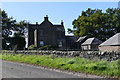
South Suttieside
Farm buildings at South Suttieside.
Image: © Mary Rodgers
Taken: 3 Sep 2020
0.15 miles
10
Suttieside Road Forfar, near its junction with Caledonian Way
At the point in the picture where the footpath is raised, trains used to run under a bridge here. The bridge has recently been demolished to make way for new housing ie: Caledonian Way.
Image: © Alan Morrison
Taken: 4 Mar 2009
0.16 miles