IMAGES TAKEN NEAR TO
FORFAR, DD8 2UE
Introduction
This page details the photographs taken nearby to DD8 2UE by members of the Geograph project.
The Geograph project started in 2005 with the aim of publishing, organising and preserving representative images for every square kilometre of Great Britain, Ireland and the Isle of Man.

There are currently over 7.5m images from over14,400 individuals and you can help contribute to the project by visiting https://www.geograph.org.uk
Image Map
Images are licensed for reuse under creativecommons.org/licenses/by-sa/2.0
Notes
- Clicking on the map will re-center to the selected point.
- The higher the marker number, the further away the image location is from the centre of the postcode.
Image Listing (10 Images Found)
Images are licensed for reuse under creativecommons.org/licenses/by-sa/2.0
Image
Details
Distance
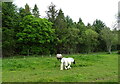
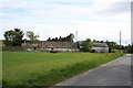
3
Horse by the Crossroads
A horse grazing by the B9113 crossroads.
Image: © Andrew Wood
Taken: 19 May 2011
0.09 miles
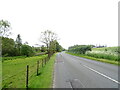
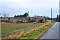
4
Junction on the B9113
Forfar to Montrose road and Milldens to Middledrums Road
Image: © Dominic Dawn Harry and Jacob Paterson
Taken: 20 Feb 2006
0.11 miles
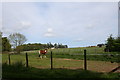
7
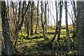
Woodland, Bents
A long established wood, shown on maps published long before these trees germinated.
Image: © Richard Webb
Taken: 11 Jan 2014
0.22 miles
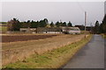
9
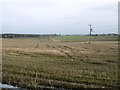
Stubble beside Montreathmont Forest
Arable land on the southern edge of Montreathmont Forest.
Image: © Richard Webb
Taken: 23 Jan 2016
0.23 miles
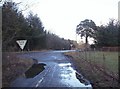
10
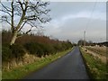
A road into Montreathmont Forest
Brechin bound through the forest.
Image: © Richard Webb
Taken: 23 Jan 2016
0.24 miles