IMAGES TAKEN NEAR TO
Clocksbriggs, FORFAR, DD8 2TD
Introduction
This page details the photographs taken nearby to DD8 2TD by members of the Geograph project.
The Geograph project started in 2005 with the aim of publishing, organising and preserving representative images for every square kilometre of Great Britain, Ireland and the Isle of Man.

There are currently over 7.5m images from over14,400 individuals and you can help contribute to the project by visiting https://www.geograph.org.uk
Image Map
Images are licensed for reuse under creativecommons.org/licenses/by-sa/2.0
Notes
- Clicking on the map will re-center to the selected point.
- The higher the marker number, the further away the image location is from the centre of the postcode.
Image Listing (26 Images Found)
Images are licensed for reuse under creativecommons.org/licenses/by-sa/2.0
Image
Details
Distance
4
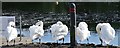
All In A Row
Rescobie Loch has sometimes as many as 50 swans and they are quite used to people and happy to have their photos taken. The loch is part of the Lunan Waters and together with its neighbour, Balgavies Loch, have been classified as a biological Site of Special Scientific Interest (SSSI code 1345) and as such both are protected and monitored. It is a diverse habitat for both wildlife and plants.
Image: © Mary Rodgers
Taken: 2 Oct 2019
0.03 miles
5
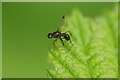
Sepsid fly, Rescobie Loch, Forfar
Sepsid flies are sometimes known as Lesser Dung Flies, because of their breeding habits and their small size, but in habits and appearance they resemble the picture-winged flies, an they attract mates in a similar fashion, by waggling their wings.
Image: © Mike Pennington
Taken: 12 Jul 2014
0.03 miles
6
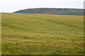
Fields at Rescobie, Forfar
Turin Hill in the background.
Image: © Mike Pennington
Taken: 12 Jul 2014
0.03 miles
7
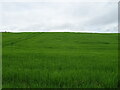
Cereal crop, Rescobie
Rises uphill from the B9113.
Image: © JThomas
Taken: 13 Jun 2021
0.03 miles
9
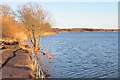
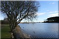
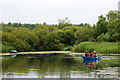
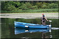
Rescobie Loch
A shallow loch in an area of glacial depositional features. The view is from the angling club and the water level is quite high.
Image: © Richard Webb
Taken: 11 Jan 2014
0.05 miles
10

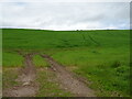
Fields, Rescobie
A burn drains to Rescobie Loch.
Image: © Richard Webb
Taken: 11 Jan 2014
0.05 miles