IMAGES TAKEN NEAR TO
Letham, FORFAR, DD8 2ND
Introduction
This page details the photographs taken nearby to DD8 2ND by members of the Geograph project.
The Geograph project started in 2005 with the aim of publishing, organising and preserving representative images for every square kilometre of Great Britain, Ireland and the Isle of Man.

There are currently over 7.5m images from over14,400 individuals and you can help contribute to the project by visiting https://www.geograph.org.uk
Image Map
Images are licensed for reuse under creativecommons.org/licenses/by-sa/2.0
Notes
- Clicking on the map will re-center to the selected point.
- The higher the marker number, the further away the image location is from the centre of the postcode.
Image Listing (3 Images Found)
Images are licensed for reuse under creativecommons.org/licenses/by-sa/2.0
Image
Details
Distance
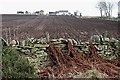
1
Hillhead from Clearbank
Unusually, the whole of this square is visible from here. Clearbank is just behind me, and Hillhead is almost at the far side of the square.
Image: © Anne Burgess
Taken: 21 Feb 2008
0.01 miles
2
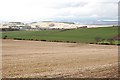
Hillhead
Recently ploughed furrows draw the eye to the farm house.
Image: © Anne Burgess
Taken: 21 Feb 2008
0.02 miles
3

Potatoes, Hillhead
Below Clearhills (background).
Image: © Richard Webb
Taken: 1 Sep 2018
0.22 miles