IMAGES TAKEN NEAR TO
Lour Road, FORFAR, DD8 2LD
Introduction
This page details the photographs taken nearby to Lour Road, DD8 2LD by members of the Geograph project.
The Geograph project started in 2005 with the aim of publishing, organising and preserving representative images for every square kilometre of Great Britain, Ireland and the Isle of Man.

There are currently over 7.5m images from over14,400 individuals and you can help contribute to the project by visiting https://www.geograph.org.uk
Image Map
Images are licensed for reuse under creativecommons.org/licenses/by-sa/2.0
Notes
- Clicking on the map will re-center to the selected point.
- The higher the marker number, the further away the image location is from the centre of the postcode.
Image Listing (11 Images Found)
Images are licensed for reuse under creativecommons.org/licenses/by-sa/2.0
Image
Details
Distance
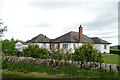
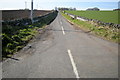
2
Forfar / Lour Road at its junction with the Balmashanner / Kingsmuir Road
This junction also forms part of the Forfar Path Network.
Image: © Alan Morrison
Taken: 27 Aug 2007
0.02 miles
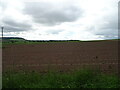
3
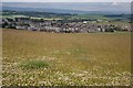
Clover field at Pitreuchie
Beyond the clover field are the outskirts of Forfar, and in the distance are the foothills of the Grampian Mountains.
Image: © Anne Burgess
Taken: 26 Jun 2006
0.05 miles
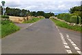
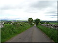
4
Road to Balmashanner
Looking down the steep hill from Balmashanner towards the Lour Road.
Image: © Scott Cormie
Taken: 17 Oct 2017
0.06 miles
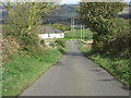
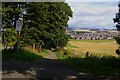
5
Road leading to Balmashanner Farm from the Forfar / Caldhame Road
Picture taken looking southwest.
Image: © Alan Morrison
Taken: 17 Mar 2009
0.07 miles
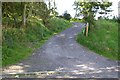
8
Path from Lour Road, Forfar leading to Easterbank, Forfar
This path is part of Forfar Path Network.
Image: © Alan Morrison
Taken: 27 Aug 2007
0.14 miles
9
Path from Lour Road, Forfar leading to Balmashanner Hill
This is part of Forfar Path Network and Balmashanner Hill is a Viewpoint.
Image: © Alan Morrison
Taken: 27 Aug 2007
0.16 miles
10
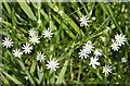
Lesser Stitchwort (Stellaria graminea)
A common wild flower in the roadside verges.
Image: © Anne Burgess
Taken: 26 Jun 2006
0.17 miles