IMAGES TAKEN NEAR TO
FORFAR, DD8 1XR
Introduction
This page details the photographs taken nearby to DD8 1XR by members of the Geograph project.
The Geograph project started in 2005 with the aim of publishing, organising and preserving representative images for every square kilometre of Great Britain, Ireland and the Isle of Man.

There are currently over 7.5m images from over14,400 individuals and you can help contribute to the project by visiting https://www.geograph.org.uk
Image Map
Images are licensed for reuse under creativecommons.org/licenses/by-sa/2.0
Notes
- Clicking on the map will re-center to the selected point.
- The higher the marker number, the further away the image location is from the centre of the postcode.
Image Listing (5 Images Found)
Images are licensed for reuse under creativecommons.org/licenses/by-sa/2.0
Image
Details
Distance
1
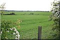
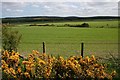
Gallowfauld
Extensive arable fields at Gallowfauld, with a glimpse of the traffic on the A90 on the right.
Image: © Anne Burgess
Taken: 22 May 2007
0.06 miles
2
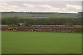
Ploughing at Gallowfauld
Gulls follow the two tractors preparing the fields.
Image: © Mike Pennington
Taken: 4 May 2009
0.15 miles
3
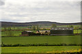
Gallowfauld, between Forfar and Dundee
Image: © Mike Pennington
Taken: 8 Jun 2015
0.21 miles
5
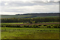
East Gallowfauld
East Gallowfauld is the house at extreme left.
Image: © Anne Burgess
Taken: 22 May 2007
0.24 miles