IMAGES TAKEN NEAR TO
FORFAR, DD8 1XQ
Introduction
This page details the photographs taken nearby to DD8 1XQ by members of the Geograph project.
The Geograph project started in 2005 with the aim of publishing, organising and preserving representative images for every square kilometre of Great Britain, Ireland and the Isle of Man.

There are currently over 7.5m images from over14,400 individuals and you can help contribute to the project by visiting https://www.geograph.org.uk
Image Map
Images are licensed for reuse under creativecommons.org/licenses/by-sa/2.0
Notes
- Clicking on the map will re-center to the selected point.
- The higher the marker number, the further away the image location is from the centre of the postcode.
Image Listing (11 Images Found)
Images are licensed for reuse under creativecommons.org/licenses/by-sa/2.0
Image
Details
Distance
2
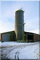
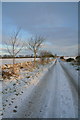
View of Nether Finlarg Farm
The road to the farm is single track. It joins the Dundee / Forfar Road (A90 dual-carriageway) about 1/4 mile south from where the picture was taken.
Image: © Alan Morrison
Taken: 6 Jan 2008
0.09 miles
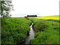
3
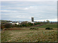
Nether Finlarg farm
The view looks north west from the track to West Tarbrax
Image: © Val Vannet
Taken: 19 Nov 2005
0.12 miles
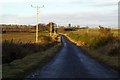
4
Road North of Nether Finlarg Farm
The trees on the left are ash trees.
Image: © Dan
Taken: 19 Dec 2009
0.14 miles
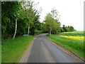
9

Road North of Nether Finlarg
View South towards Nether Finlarg.
Image: © Christopher Gillan
Taken: 19 Nov 2005
0.17 miles