IMAGES TAKEN NEAR TO
Inverarity, FORFAR, DD8 1XN
Introduction
This page details the photographs taken nearby to DD8 1XN by members of the Geograph project.
The Geograph project started in 2005 with the aim of publishing, organising and preserving representative images for every square kilometre of Great Britain, Ireland and the Isle of Man.

There are currently over 7.5m images from over14,400 individuals and you can help contribute to the project by visiting https://www.geograph.org.uk
Image Map
Images are licensed for reuse under creativecommons.org/licenses/by-sa/2.0
Notes
- Clicking on the map will re-center to the selected point.
- The higher the marker number, the further away the image location is from the centre of the postcode.
Image Listing (6 Images Found)
Images are licensed for reuse under creativecommons.org/licenses/by-sa/2.0
Image
Details
Distance
1
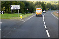
Stone bridge over burn at Gateside
The bridge is dwarfed by the large road sign near the junction to the A90.
Image: © Douglas Nelson
Taken: 29 Jun 2016
0.04 miles
2
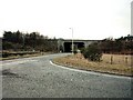
A90 Bridge near Gateside and Inverarity.
The bridge carries A90 Dundee/Aberdeen dual carriageway over "yellow" road between Gateside and Inverarity.
Image: © Christopher Gillan
Taken: 28 Jan 2006
0.13 miles

4
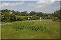
Junction on the A90 at Gateside, south of Forfar
Image: © Mike Pennington
Taken: 12 Jun 2015
0.18 miles
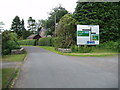
5

Kincriech Farmhouse, Gateside, near Forfar
Image: © Christopher Gillan
Taken: 28 Jan 2006
0.21 miles