IMAGES TAKEN NEAR TO
Charleston Village, FORFAR, DD8 1UF
Introduction
This page details the photographs taken nearby to Charleston Village, DD8 1UF by members of the Geograph project.
The Geograph project started in 2005 with the aim of publishing, organising and preserving representative images for every square kilometre of Great Britain, Ireland and the Isle of Man.

There are currently over 7.5m images from over14,400 individuals and you can help contribute to the project by visiting https://www.geograph.org.uk
Image Map
Images are licensed for reuse under creativecommons.org/licenses/by-sa/2.0
Notes
- Clicking on the map will re-center to the selected point.
- The higher the marker number, the further away the image location is from the centre of the postcode.
Image Listing (6 Images Found)
Images are licensed for reuse under creativecommons.org/licenses/by-sa/2.0
Image
Details
Distance
2
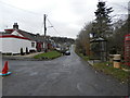
Charelston
The lovely hamlet is situated to the north-west of Dundee.
Image: © James Denham
Taken: 3 Jun 2010
0.16 miles
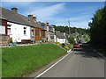
3

Charleston
Attractive rural hamlet near Glamis which consists of not much more than a main street!
Image: © Christopher Gillan
Taken: 19 Nov 2005
0.18 miles
4
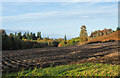
Field east of Charleston
Low-angled sunshine emphasises the ridges of this field lying east from the village of Charleston. The following day there was machinery operating there, lifting the potato crop.
Image: © Trevor Littlewood
Taken: 19 Oct 2018
0.20 miles
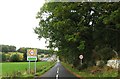
6
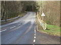
A928 road just south of Glamis
The A928 looking northbound around half a mile from Glamis.
Image: © Scott Cormie
Taken: 3 Mar 2017
0.25 miles