IMAGES TAKEN NEAR TO
Kincaldrum, FORFAR, DD8 1TY
Introduction
This page details the photographs taken nearby to DD8 1TY by members of the Geograph project.
The Geograph project started in 2005 with the aim of publishing, organising and preserving representative images for every square kilometre of Great Britain, Ireland and the Isle of Man.

There are currently over 7.5m images from over14,400 individuals and you can help contribute to the project by visiting https://www.geograph.org.uk
Image Map
Images are licensed for reuse under creativecommons.org/licenses/by-sa/2.0
Notes
- Clicking on the map will re-center to the selected point.
- The higher the marker number, the further away the image location is from the centre of the postcode.
Image Listing (6 Images Found)
Images are licensed for reuse under creativecommons.org/licenses/by-sa/2.0
Image
Details
Distance
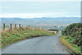
2
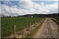
Road at Foffarty
The minor road heading downhill to Wester Foffarty, with Strathmore and the Grampians beyond.
Image: © Scott Cormie
Taken: 28 Apr 2018
0.08 miles
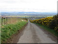
3
Wester Foffarty Farm, near Glamis
Image: © Christopher Gillan
Taken: 28 Jan 2006
0.10 miles
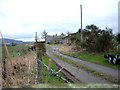
6
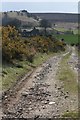
Mains of Foffarty
The farmhouse is all that remains of Mains of Foffarty farm. The building on the other side of the track shown on the 1:50.000 is no longer there.
Image: © Dan
Taken: 15 Apr 2008
0.22 miles