IMAGES TAKEN NEAR TO
Kincaldrum, FORFAR, DD8 1TW
Introduction
This page details the photographs taken nearby to DD8 1TW by members of the Geograph project.
The Geograph project started in 2005 with the aim of publishing, organising and preserving representative images for every square kilometre of Great Britain, Ireland and the Isle of Man.

There are currently over 7.5m images from over14,400 individuals and you can help contribute to the project by visiting https://www.geograph.org.uk
Image Map
Images are licensed for reuse under creativecommons.org/licenses/by-sa/2.0
Notes
- Clicking on the map will re-center to the selected point.
- The higher the marker number, the further away the image location is from the centre of the postcode.
Image Listing (8 Images Found)
Images are licensed for reuse under creativecommons.org/licenses/by-sa/2.0
Image
Details
Distance
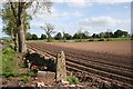
3
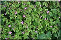
Herb Robert (Geranium robertianum)
the roadside here was thickly carpeted with the modest flowers of this common wild geranium.
Image: © Anne Burgess
Taken: 22 May 2007
0.14 miles
4
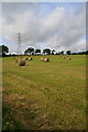
Hay bales near Washingdales
The eastern slopes of Kincaldrum Hill are used for grazing. The western slopes are grousemoor.
Image: © Dan
Taken: 9 Aug 2009
0.15 miles
5
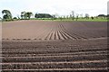
Washingdales
Furrow patterns on the fields below Washingdales.
Image: © Anne Burgess
Taken: 22 May 2007
0.16 miles
6
Washingdales
Recently ploughed land, presumably planted with potatoes.
Image: © Anne Burgess
Taken: 22 May 2007
0.21 miles
7
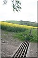
Kincaldrum
A field of rape with Kincaldrum Hill beyond.
Image: © Anne Burgess
Taken: 22 May 2007
0.22 miles