IMAGES TAKEN NEAR TO
Kinnettles, FORFAR, DD8 1TP
Introduction
This page details the photographs taken nearby to DD8 1TP by members of the Geograph project.
The Geograph project started in 2005 with the aim of publishing, organising and preserving representative images for every square kilometre of Great Britain, Ireland and the Isle of Man.

There are currently over 7.5m images from over14,400 individuals and you can help contribute to the project by visiting https://www.geograph.org.uk
Image Map
Images are licensed for reuse under creativecommons.org/licenses/by-sa/2.0
Notes
- Clicking on the map will re-center to the selected point.
- The higher the marker number, the further away the image location is from the centre of the postcode.
Image Listing (24 Images Found)
Images are licensed for reuse under creativecommons.org/licenses/by-sa/2.0
Image
Details
Distance

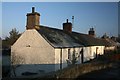
5
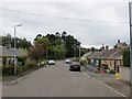
Kerbet Place, Douglastown
Now a no through road.
Image: © Richard Webb
Taken: 8 Oct 2013
0.12 miles
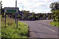
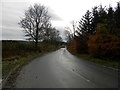
7
Douglastown near Forfar
A hamlet near Forfar.
Image: © Christopher Gillan
Taken: 28 Jan 2006
0.13 miles
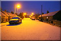
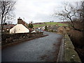
10
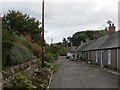
Douglastown
A row of cottages off Kerbet Place.
Image: © Richard Webb
Taken: 8 Oct 2013
0.15 miles