IMAGES TAKEN NEAR TO
FORFAR, DD8 1TH
Introduction
This page details the photographs taken nearby to DD8 1TH by members of the Geograph project.
The Geograph project started in 2005 with the aim of publishing, organising and preserving representative images for every square kilometre of Great Britain, Ireland and the Isle of Man.

There are currently over 7.5m images from over14,400 individuals and you can help contribute to the project by visiting https://www.geograph.org.uk
Image Map
Images are licensed for reuse under creativecommons.org/licenses/by-sa/2.0
Notes
- Clicking on the map will re-center to the selected point.
- The higher the marker number, the further away the image location is from the centre of the postcode.
Image Listing (10 Images Found)
Images are licensed for reuse under creativecommons.org/licenses/by-sa/2.0
Image
Details
Distance
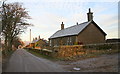
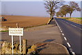
2
Road leading to Mains of Brigton
Picture taken from its junction with Meigle / Forfar road.
Image: © Alan Morrison
Taken: 1 Jan 2006
0.06 miles
6
Meigle / Forfar Road at its junction with East & Mid Ingliston Road
Photo taken looking east.
Image: © Alan Morrison
Taken: 1 Jan 2006
0.14 miles
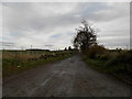
7
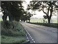
A94 westbound
The A94 road west of Forfar heading down the hill towards Douglastown.
Image: © Scott Cormie
Taken: 24 Oct 2016
0.15 miles
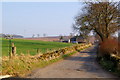
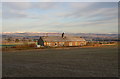
8
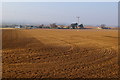
Ingliston
In midwinter the ploughed fields of Strathmore await the crops to be planted in spring
Image: © Anne Burgess
Taken: Unknown
0.15 miles
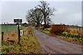
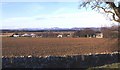
10
View of East Ingliston near Forfar
Photo taken from Meigle / Forfar Road about 300 yards west of its junction with the road leading to East and Mid Ingliston.
Image: © Alan Morrison
Taken: 1 Jan 2006
0.25 miles