IMAGES TAKEN NEAR TO
Eassie, FORFAR, DD8 1ST
Introduction
This page details the photographs taken nearby to DD8 1ST by members of the Geograph project.
The Geograph project started in 2005 with the aim of publishing, organising and preserving representative images for every square kilometre of Great Britain, Ireland and the Isle of Man.

There are currently over 7.5m images from over14,400 individuals and you can help contribute to the project by visiting https://www.geograph.org.uk
Image Map
Images are licensed for reuse under creativecommons.org/licenses/by-sa/2.0
Notes
- Clicking on the map will re-center to the selected point.
- The higher the marker number, the further away the image location is from the centre of the postcode.
Image Listing (10 Images Found)
Images are licensed for reuse under creativecommons.org/licenses/by-sa/2.0
Image
Details
Distance
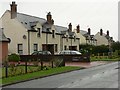
1
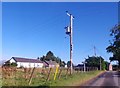
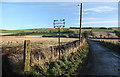
Balkeerie village
On minor road from Newtyle to Glamis.
Image: © Stanley Howe
Taken: 8 Oct 2015
0.03 miles
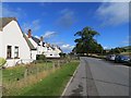
2
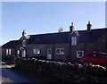
Semi-detached cottages, Balkeerie
By minor road through village to Glamis.
Image: © Stanley Howe
Taken: 8 Oct 2015
0.08 miles
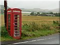
3
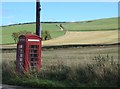
Telephone box, Balkeerie
Appears to be sinking into the earth.
Image: © Richard Webb
Taken: 8 Oct 2013
0.10 miles
4
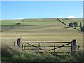
Gate, Balkeerie
Arable land on the north side of the Sidlaw Hills.
Image: © Richard Webb
Taken: 8 Oct 2013
0.10 miles
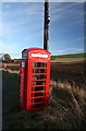
7
Balkeerie phone box
Beyond is the farm of East Nevay. Taken on a wet day.
Image: © Rob Burke
Taken: 5 Aug 2007
0.14 miles
10
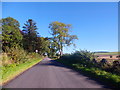
Approach to North Nevay, Balkeerie
On minor road; entering 30mph speed limit.
Image: © Stanley Howe
Taken: 8 Oct 2015
0.20 miles