IMAGES TAKEN NEAR TO
Eassie, FORFAR, DD8 1SQ
Introduction
This page details the photographs taken nearby to DD8 1SQ by members of the Geograph project.
The Geograph project started in 2005 with the aim of publishing, organising and preserving representative images for every square kilometre of Great Britain, Ireland and the Isle of Man.

There are currently over 7.5m images from over14,400 individuals and you can help contribute to the project by visiting https://www.geograph.org.uk
Image Map
Images are licensed for reuse under creativecommons.org/licenses/by-sa/2.0
Notes
- Clicking on the map will re-center to the selected point.
- The higher the marker number, the further away the image location is from the centre of the postcode.
Image Listing (8 Images Found)
Images are licensed for reuse under creativecommons.org/licenses/by-sa/2.0
Image
Details
Distance
1
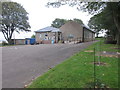
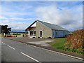
Eassie Primary School
Eassie Primary School, viewed from the Newtyle to Glamis road.
Image: © Scott Cormie
Taken: 22 Sep 2019
0.02 miles
2
Eassie School
Small Primary School. There is a modern extension behind the original building.
Image: © Christopher Gillan
Taken: 19 Nov 2005
0.07 miles
4
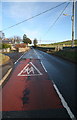
Road, Eassie
Approaching Eassie School.
Image: © Richard Webb
Taken: 8 Oct 2013
0.09 miles
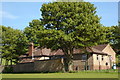
5
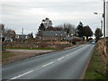
Eassie and Nevay Hall
Village hall, Eassie.
Image: © Richard Webb
Taken: 8 Oct 2013
0.13 miles
6
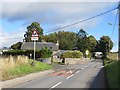
Rear aspect of Eassie School
This image is clearer than the front aspect of the school already submitted.
Image: © Sylvia Barrow
Taken: 2 Jun 2006
0.15 miles
7
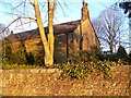
Eassie Church
A small oblong church bathed in evening light.
Image: © Maigheach-gheal
Taken: 1 Apr 2010
0.19 miles
8
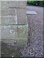
Bench Mark, Eassie Church
Bench mark on the northwest side of the church. For a view of the church see Image and http://www.bench-marks.org.uk/bm34355
A bench mark is an Ordnance Survey arrowhead sign found on walls, bridges, churches and specially erected triangulation pillars where the altitude above sea-level has been accurately measured by surveyors. The arrowhead points to a horizontal line above it or down in this particular case which marks the exact altitude.
With rivets and pivots there is no datum (horizontal line) cut, the pointed-to horizontal surface defining the datum height.
Image: © Maigheach-gheal
Taken: 1 Apr 2010
0.21 miles