IMAGES TAKEN NEAR TO
Eassie, FORFAR, DD8 1SP
Introduction
This page details the photographs taken nearby to DD8 1SP by members of the Geograph project.
The Geograph project started in 2005 with the aim of publishing, organising and preserving representative images for every square kilometre of Great Britain, Ireland and the Isle of Man.

There are currently over 7.5m images from over14,400 individuals and you can help contribute to the project by visiting https://www.geograph.org.uk
Image Map
Images are licensed for reuse under creativecommons.org/licenses/by-sa/2.0
Notes
- Clicking on the map will re-center to the selected point.
- The higher the marker number, the further away the image location is from the centre of the postcode.
Image Listing (7 Images Found)
Images are licensed for reuse under creativecommons.org/licenses/by-sa/2.0
Image
Details
Distance
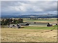
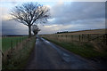
3
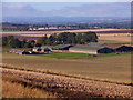
Ingliston farmstead
Seen from the minor road near Ingliston Wood villa.
Image: © Stanley Howe
Taken: 8 Oct 2015
0.06 miles
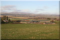
5
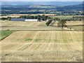
Stubble, Ingliston
Strathmore, after the harvest.
Image: © Richard Webb
Taken: 8 Oct 2013
0.16 miles
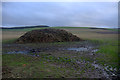
7
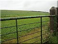
Through a gate, wetly
The afternoon's persistent rain is collecting in big drops on the field gate.
Image: © Lis Burke
Taken: 5 Aug 2007
0.23 miles