IMAGES TAKEN NEAR TO
FORFAR, DD8 1SB
Introduction
This page details the photographs taken nearby to DD8 1SB by members of the Geograph project.
The Geograph project started in 2005 with the aim of publishing, organising and preserving representative images for every square kilometre of Great Britain, Ireland and the Isle of Man.

There are currently over 7.5m images from over14,400 individuals and you can help contribute to the project by visiting https://www.geograph.org.uk
Image Map
Images are licensed for reuse under creativecommons.org/licenses/by-sa/2.0
Notes
- Clicking on the map will re-center to the selected point.
- The higher the marker number, the further away the image location is from the centre of the postcode.
Image Listing (5 Images Found)
Images are licensed for reuse under creativecommons.org/licenses/by-sa/2.0
Image
Details
Distance
1
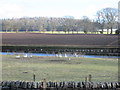
Fowl at Newton of Glamis
The roadside residents of the Newton of Glamis.
Image: © Scott Cormie
Taken: 9 Mar 2018
0.04 miles
2
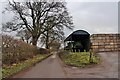
The road to Bridgend at Newton of Glamis
Potato boxes stacked ready for next year's crop.
Image: © Alan Reid
Taken: 13 Dec 2016
0.06 miles
3
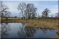
Pond, Newton of Glamis
The A94 runs through this pond, and the water on the north side of the road was inhabited by farm geese.
Image: © Richard Webb
Taken: 29 Mar 2015
0.06 miles
4
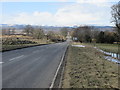
A94, west of Glamis
The A94 heading downhill to the Newton of Glamis with the snow covered Grampians in the distance.
Image: © Scott Cormie
Taken: 9 Mar 2018
0.15 miles
5
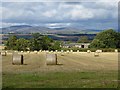
Round bales, Glamis
Straw bales in Strathmore.
Image: © Richard Webb
Taken: 8 Oct 2013
0.23 miles