IMAGES TAKEN NEAR TO
Roundyhill, FORFAR, DD8 1QS
Introduction
This page details the photographs taken nearby to DD8 1QS by members of the Geograph project.
The Geograph project started in 2005 with the aim of publishing, organising and preserving representative images for every square kilometre of Great Britain, Ireland and the Isle of Man.

There are currently over 7.5m images from over14,400 individuals and you can help contribute to the project by visiting https://www.geograph.org.uk
Image Map
Images are licensed for reuse under creativecommons.org/licenses/by-sa/2.0
Notes
- Clicking on the map will re-center to the selected point.
- The higher the marker number, the further away the image location is from the centre of the postcode.
Image Listing (6 Images Found)
Images are licensed for reuse under creativecommons.org/licenses/by-sa/2.0
Image
Details
Distance
1
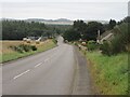
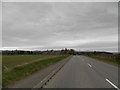
A928 southbound at Roundyhill
The A928 heading south to Glamis from Kirriemuir at Roundyhill.
Image: © Scott Cormie
Taken: 22 Sep 2023
0.19 miles
2
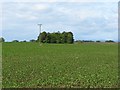
Roundyhill
Flat arable land. The trees are missing from the maps.
Image: © Richard Webb
Taken: 19 May 2007
0.22 miles
3
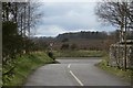
Road junction, Roundyhill
Beside the site of Roundyhill School.
Image: © Richard Webb
Taken: 29 Mar 2015
0.22 miles
5
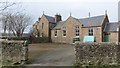
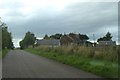
Roundyhill School
Building of a closed school.
Image: © Richard Webb
Taken: 29 Mar 2015
0.24 miles