IMAGES TAKEN NEAR TO
FORFAR, DD8 1QE
Introduction
This page details the photographs taken nearby to DD8 1QE by members of the Geograph project.
The Geograph project started in 2005 with the aim of publishing, organising and preserving representative images for every square kilometre of Great Britain, Ireland and the Isle of Man.

There are currently over 7.5m images from over14,400 individuals and you can help contribute to the project by visiting https://www.geograph.org.uk
Image Map
Images are licensed for reuse under creativecommons.org/licenses/by-sa/2.0
Notes
- Clicking on the map will re-center to the selected point.
- The higher the marker number, the further away the image location is from the centre of the postcode.
Image Listing (7 Images Found)
Images are licensed for reuse under creativecommons.org/licenses/by-sa/2.0
Image
Details
Distance
1
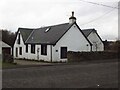
Toll House, A928 Glamis
On the West side of the road from Glamis to Kirriemuir. Commonly known as Roundthill Toll House.
Milestone Society National ID: AN.FOR02
Image: © Paul Hornby
Taken: 19 Mar 2023
0.07 miles
2
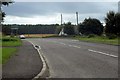
Kirriemuir / Glamis Road at Powmyre Junction
Image: © Alan Morrison
Taken: 11 Sep 2008
0.09 miles
3
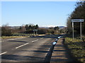
A928 south of Roundyhill
The A928 Glamis to Kirriemuir road approaching Roundyhill from the south.
Image: © Scott Cormie
Taken: 1 Apr 2018
0.11 miles
4
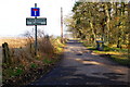
Road leading to Meikle Cossans
Picture taken from its junction with the Kirriemuir / Glamis Road. The sign shows Miekle Cossans - Could this be a mistake or am I wrong?
Image: © Alan Morrison
Taken: 1 Jan 2006
0.12 miles
5
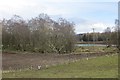
Flooded ground near Claypots
Looking through a wood to an unmapped water feature, probably seasonal.
Image: © Richard Webb
Taken: 29 Mar 2015
0.17 miles
6
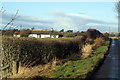
Greenbank Farm, Roundyhill
The photo was taken from the roadway, quite near to the Kirriemuir / Glamis junction
Image: © Alan Morrison
Taken: 13 Jan 2009
0.21 miles
7
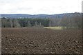
Fields, Leys of Cossans
Arable land being prepared for planting spring cereals, probably barley for malting. Old maps show numerous small strip fields here.
Image: © Richard Webb
Taken: 29 Mar 2015
0.23 miles