IMAGES TAKEN NEAR TO
FORFAR, DD8 1QA
Introduction
This page details the photographs taken nearby to DD8 1QA by members of the Geograph project.
The Geograph project started in 2005 with the aim of publishing, organising and preserving representative images for every square kilometre of Great Britain, Ireland and the Isle of Man.

There are currently over 7.5m images from over14,400 individuals and you can help contribute to the project by visiting https://www.geograph.org.uk
Image Map
Images are licensed for reuse under creativecommons.org/licenses/by-sa/2.0
Notes
- Clicking on the map will re-center to the selected point.
- The higher the marker number, the further away the image location is from the centre of the postcode.
Image Listing (7 Images Found)
Images are licensed for reuse under creativecommons.org/licenses/by-sa/2.0
Image
Details
Distance
1
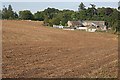
Mains of Ballindarg
Cottages and farm buildings beside a harvested field.
Image: © Anne Burgess
Taken: 17 Aug 2006
0.01 miles
2
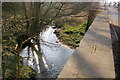
Gairie Burn at the road bridge at Mains of Ballindarg
Mains of Ballindarg Cottages can be seen in the background.
Image: © Alan Morrison
Taken: 1 Jan 2006
0.05 miles
3
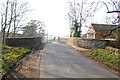
Bridge over Gairie Burn at Mains of Ballindarg, near Forfar
Picture taken looking west.
Image: © Alan Morrison
Taken: 1 Jan 2006
0.09 miles
4
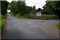
Padanaram / Roundyhill Road at its junction with the road leading to Maryton
Image: © Alan Morrison
Taken: 28 Aug 2007
0.20 miles
5
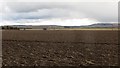
Ploughed fields, Ballindarg
Spring arable in Strathmore.
Image: © Richard Webb
Taken: 29 Mar 2015
0.22 miles
6
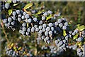
Berberis Darwinii
A plentiful supply of berries in a cottage garden by the track at West Mains of Ballindarg.
Image: © Anne Burgess
Taken: 17 Aug 2006
0.23 miles
7
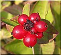
Honeysuckle (Lonicera periclymenum)
Attractive but poisonous berries.
Image: © Anne Burgess
Taken: 17 Aug 2006
0.23 miles