IMAGES TAKEN NEAR TO
Laurel Bank, FORFAR, DD8 1LQ
Introduction
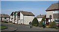
This page details the photographs taken nearby to Laurel Bank, DD8 1LQ by members of the Geograph project.
The Geograph project started in 2005 with the aim of publishing, organising and preserving representative images for every square kilometre of Great Britain, Ireland and the Isle of Man.

There are currently over 7.5m images from over14,400 individuals and you can help contribute to the project by visiting https://www.geograph.org.uk
Image Map
Images are licensed for reuse under creativecommons.org/licenses/by-sa/2.0
Notes
- Clicking on the map will re-center to the selected point.
- The higher the marker number, the further away the image location is from the centre of the postcode.
Image Listing (177 Images Found)
Images are licensed for reuse under creativecommons.org/licenses/by-sa/2.0
Image
Details
Distance
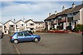
1
Lyninghills
This small council housing estate occupies what was a field and market garden until the 1970s. It is a maze of culs-de-sac off St James' Road.
Image: © Anne Burgess
Taken: 20 Apr 2009
0.02 miles
2
Lyninghills
This small council housing estate occupies what was a field and market garden until the 1970s. It is a maze of culs-de-sac off St James' Road. To the right is the Georgian façade of Ravenswood, with the Steeple visible above the ugly office block in the former grounds of Ravenswood.
Image: © Anne Burgess
Taken: 20 Apr 2009
0.02 miles
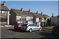
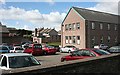
3
Laurelbank
There is a warren of culs-de-sac in this development, which takes its name from a large house in the grounds of which the housing estate was built.
Image: © Anne Burgess
Taken: 13 Aug 2010
0.03 miles
4
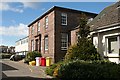
Ravenswood
This Georgian House, sadly flanked by one of the worst examples of instant 20th-century 'temporary' buildings, was the local health clinic but now houses the offices of the Regional Assessor. I hope that the dustbins are in such a prominent spot only because it is bin day, but I fear that the yellow plastic container of sand and salt is permanent.
Image: © Anne Burgess
Taken: 17 Apr 2007
0.05 miles
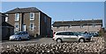
5
Ravenswood
The modern block on the right is the offices of the health board. I don't know what use is made of the blockhouse beyond, whixch looks as if it was left over from the War.
Image: © Anne Burgess
Taken: 17 Apr 2007
0.05 miles
6
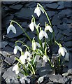
Snowdrops
As soon as the recent deep snow melted, snowdrops have appeared all over the place. These ones are in a garden in New Road, and have pushed their way up through a layer of slate chips.
Image: © Anne Burgess
Taken: 18 Feb 2009
0.05 miles
7
Rosemount
Just off New Road, the original house, on the left, has been converted into flats, and its gardens filled up with council housing and parking.
Image: © Anne Burgess
Taken: 20 Apr 2009
0.06 miles
8
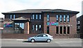
Ramsay Ladders Headquarters
Ramsay Ladders is a successful Forfar company, which has made its name and reputation manufacturing disappearing loft ladders. See http://www.ramsayladders.co.uk/
Image: © Anne Burgess
Taken: 13 Aug 2010
0.06 miles
9
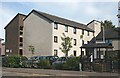
Springfield Sheltered Housing
Springfield is a block of modern council-run sheltered housing for elderly people.
Image: © Anne Burgess
Taken: 13 Aug 2010
0.06 miles
10
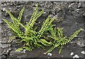
Maidenhair Spleenwort (Asplenium trichomanes)
The black stems are unique to this species of spleenwort, which has colonised the east side of this garden wall.
Image: © Anne Burgess
Taken: 19 Jun 2009
0.06 miles