IMAGES TAKEN NEAR TO
Craig O'Loch Road, FORFAR, DD8 1BT
Introduction
This page details the photographs taken nearby to Craig O'Loch Road, DD8 1BT by members of the Geograph project.
The Geograph project started in 2005 with the aim of publishing, organising and preserving representative images for every square kilometre of Great Britain, Ireland and the Isle of Man.

There are currently over 7.5m images from over14,400 individuals and you can help contribute to the project by visiting https://www.geograph.org.uk
Image Map
Images are licensed for reuse under creativecommons.org/licenses/by-sa/2.0
Notes
- Clicking on the map will re-center to the selected point.
- The higher the marker number, the further away the image location is from the centre of the postcode.
Image Listing (115 Images Found)
Images are licensed for reuse under creativecommons.org/licenses/by-sa/2.0
Image
Details
Distance
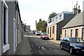
2
Manor Street, Forfar
Picture taken from near its junction with Craig O' Loch Road, looking east.
Image: © Alan Morrison
Taken: 3 Mar 2009
0.03 miles
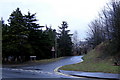
3
View of Craig O' Loch Road, Forfar
Picture taken looking south from its junction with Queenswell Road.
Image: © Alan Morrison
Taken: 16 Mar 2009
0.04 miles
5
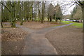
Paths leading to Forfar Leisure Centre
Photo taken looking west from Craig O' Loch Road.
Image: © Alan Morrison
Taken: 16 Mar 2009
0.07 miles
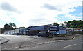
6
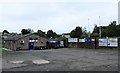
Forfar West End
Forfar West End amateur football ground and social club.
Image: © Mary Rodgers
Taken: 27 Aug 2020
0.07 miles
7
Trees in front of Forfar Leisure Centre
Image: © Mike Pennington
Taken: 1 Aug 2010
0.09 miles
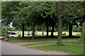
8
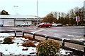
View of Focus premises at Myre Road, Forfar
Picture taken from north end of Stark's Close. The Myre park is in the foreground.
Image: © Alan Morrison
Taken: 3 Mar 2009
0.10 miles
9
Manor Street, Forfar
Picture taken from Annfield lane,looking westwards.
Image: © Alan Morrison
Taken: 17 Mar 2009
0.10 miles
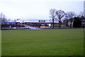
10
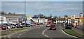
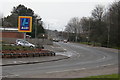
Queenswell Road
This was originally Queenswell Lane, a quiet byway. The former A92 trunk road was diverted round the town centre, and the usual series of commercial enterprises sprang up alongside it. At some stage its name was changed from Lane to Road. In its turn it has been bypassed by the A90 dual carriageway a mile or so to the west. The crowstepped gables of the town's Reid Hall appear above the Vauxhall logo on the left.
Image: © Anne Burgess
Taken: 16 Apr 2007
0.10 miles