IMAGES TAKEN NEAR TO
West High Street, FORFAR, DD8 1BB
Introduction
This page details the photographs taken nearby to West High Street, DD8 1BB by members of the Geograph project.
The Geograph project started in 2005 with the aim of publishing, organising and preserving representative images for every square kilometre of Great Britain, Ireland and the Isle of Man.

There are currently over 7.5m images from over14,400 individuals and you can help contribute to the project by visiting https://www.geograph.org.uk
Image Map
Images are licensed for reuse under creativecommons.org/licenses/by-sa/2.0
Notes
- Clicking on the map will re-center to the selected point.
- The higher the marker number, the further away the image location is from the centre of the postcode.
Image Listing (223 Images Found)
Images are licensed for reuse under creativecommons.org/licenses/by-sa/2.0
Image
Details
Distance
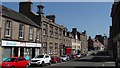
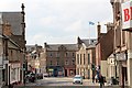
2
West High Street
East and West High Street are effectively a single street, which changes its name at the Cross. The pink building at the far end of this view is the first building in East High Street. The taller building with the cupola and weather vane is the Meffan Institute, which houses the Museum and exhibition space. Of particular interest in the Museum is the reconstruction of an old Forfar street, with a full range of small shops.
Image: © Anne Burgess
Taken: 17 Apr 2007
0.01 miles
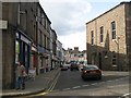
4
The Cross, Forfar
The centre of the town of Forfar at the cross, looking down East High Street towards the Town Hall.
Image: © Scott Cormie
Taken: 26 Feb 2017
0.03 miles
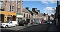
5
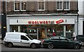
Woolworths No More
Woolworths has been a presence just here for as long as most of the town's inhabitants can recall, but it closed down at the end of December 2008 when the company went bust.
I have been asked by his son to add that the gentleman in the light coloured jacket is the late Charles Balfour Lyon (Chick) 1927-2016.
Image: © Anne Burgess
Taken: 30 Dec 2008
0.03 miles
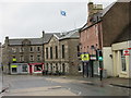
7
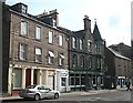
8 - 14 The Cross
I always thought that these buildings were the lowest-numbered ones in West High Street, but the listed buildings register describes them as numbers 8 to 14, The Cross. The group is listed Category C(S). The building with the turret and green paint is the Queen's Hotel, built in 1885.
Image: © Anne Burgess
Taken: 2 Apr 2010
0.03 miles
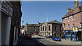
8
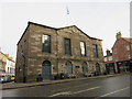
Forfar Town Hall
The town hall in Forfar at The Cross.
Image: © Scott Cormie
Taken: 19 Feb 2017
0.03 miles
9
Forfar Town Hall
The saltire flies over the town hall.
Image: © Bob Embleton
Taken: 14 Aug 2012
0.03 miles
10
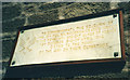
Polish plaque at Forfar Cross
This plaque is situated on a wall at the Cross, on your right just as you turn left from West High Street into Castle Street. It commemorates the stay between 1940 and 1942 of a Polish unit in Forfar which later took part in the Normandy campaign.
Image: © Stephen Stachowiak
Taken: 27 Apr 2007
0.03 miles