IMAGES TAKEN NEAR TO
Mansefield Lane, CARNOUSTIE, DD7 7SJ
Introduction
This page details the photographs taken nearby to Mansefield Lane, DD7 7SJ by members of the Geograph project.
The Geograph project started in 2005 with the aim of publishing, organising and preserving representative images for every square kilometre of Great Britain, Ireland and the Isle of Man.

There are currently over 7.5m images from over14,400 individuals and you can help contribute to the project by visiting https://www.geograph.org.uk
Image Map
Images are licensed for reuse under creativecommons.org/licenses/by-sa/2.0
Notes
- Clicking on the map will re-center to the selected point.
- The higher the marker number, the further away the image location is from the centre of the postcode.
Image Listing (14 Images Found)
Images are licensed for reuse under creativecommons.org/licenses/by-sa/2.0
Image
Details
Distance
1
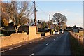
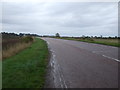
Barry
The village is now bypassed to the south by the A930.
Image: © Richard Webb
Taken: 24 Dec 2014
0.07 miles
4
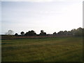
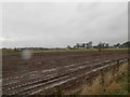
Farmland, Barry to the West.
The fields here are bisected by a drainage ditch lined with reeds. To the right are buildings on the raised beach. The trees central are around the old church manse which is on a slightly raised area. This is currently being rebuilt. To the right of this is some modern housing.
Image: © Gwen and James Anderson
Taken: 28 May 2007
0.15 miles
5
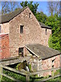
Barry Mill
Barry Mill is a 19th century water powered mill which was used for grinding oats into oatmeal. It is in the care of the National Trust for Scotland.
Image: © Val Vannet
Taken: 13 May 2005
0.17 miles
6
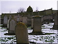
Barry Kirkyard
The gravestone of Tammas Louson - founding father of Carnoustie is shown here (centre right)
Image: © Karen Vernon
Taken: 13 Mar 2006
0.17 miles
7
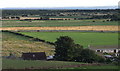
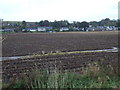
View across Barry
Taken from above the western end of the village. The newly built by-pass can clearly seen. Beyond this a narrow strip of fields before the golf course, his in turn gives way to Barry Buddon. The two disused lighthouses can be seen in the distance.
Image: © Gwen and James Anderson
Taken: 2 Sep 2007
0.17 miles
8
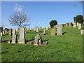
Barry Cemetery
The cemetery at Barry, looking westwards from near the entrance.
Image: © Scott Cormie
Taken: 6 May 2018
0.19 miles
9
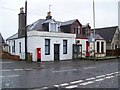
Village communications, Barry
A George V reign postbox and a modern telephone box in the centre of the village.
Image: © Maigheach-gheal
Taken: 30 Mar 2010
0.19 miles