IMAGES TAKEN NEAR TO
Ravensby Road, CARNOUSTIE, DD7 7NN
Introduction
This page details the photographs taken nearby to Ravensby Road, DD7 7NN by members of the Geograph project.
The Geograph project started in 2005 with the aim of publishing, organising and preserving representative images for every square kilometre of Great Britain, Ireland and the Isle of Man.

There are currently over 7.5m images from over14,400 individuals and you can help contribute to the project by visiting https://www.geograph.org.uk
Image Map
Images are licensed for reuse under creativecommons.org/licenses/by-sa/2.0
Notes
- Clicking on the map will re-center to the selected point.
- The higher the marker number, the further away the image location is from the centre of the postcode.
Image Listing (13 Images Found)
Images are licensed for reuse under creativecommons.org/licenses/by-sa/2.0
Image
Details
Distance
1
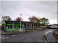
Veterinary Centre and Newsagents
Wallace Vets which opened here in August of 2004 alongside Angus's Carnoustie Food Store, which had closed for the evening in this photo.
Image: © Ross Murison
Taken: 19 May 2021
0.09 miles
2
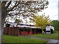
The Craws Nest Pub
Complete with covid-era gazebos.
Image: © Ross Murison
Taken: 19 May 2021
0.09 miles
3
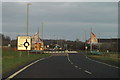
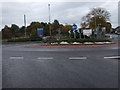
Monifieth / Carnoustie / Barry Roundabout
Image: © Alan Morrison
Taken: 29 Dec 2008
0.12 miles
4
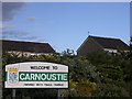
Welcome to Carnoustie
The sign at the western approach to Carnoustie on the A930
Image: © Val Vannet
Taken: 9 Jun 2005
0.13 miles
5
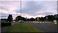
Roundabout on Barry Road (A930), Carnoustie
Image: © JThomas
Taken: 23 Oct 2013
0.15 miles
6
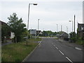
Roundabout on the Barry Road, Carnoustie
From this direction: 1st Exit is for Westfield Street, 2nd is for Barry road (A930) and 3rd is up to Upper Victoria and the A92.
Image: © Ross Murison
Taken: 18 Sep 2016
0.15 miles
7
Station Road in Barry, Angus.
Heading from the kirk to A930.
Image: © James Denham
Taken: 1 Jun 2010
0.17 miles
8
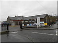
Former school in Barry
Now a business centre
Image: © Douglas Nelson
Taken: 12 Nov 2014
0.18 miles
9
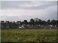
Barry, East end
Barry village is a linear settlement with settlement historically confined to the raised beach on the north side of the road, the southern area being marsh and subject to flooding from the Barry Burn. The burn is now controlled by high concrete banks and the new bypass, which runs through the mid ground of the photo across the fields which still flood badly. The church spire to the left is Barry Parish Kirk which was originally built as the 'Free Kirk'. To its right is the former manse. The building in the middle is Barry Primary School (due to close this year) which was a plash mill before it became the 'Free Church' school. The houses to the right and behind the school were built during the 1980's and those to the left, above the church, were built in the last couple of years on the site of 3 cottages.
Image: © Gwen and James Anderson
Taken: 28 May 2007
0.20 miles
10
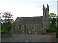
Barry Parish Church
In Barry, Angus near Dundee.
Image: © James Denham
Taken: 1 Jun 2010
0.21 miles