IMAGES TAKEN NEAR TO
Thomas Street, CARNOUSTIE, DD7 7LL
Introduction
This page details the photographs taken nearby to Thomas Street, DD7 7LL by members of the Geograph project.
The Geograph project started in 2005 with the aim of publishing, organising and preserving representative images for every square kilometre of Great Britain, Ireland and the Isle of Man.

There are currently over 7.5m images from over14,400 individuals and you can help contribute to the project by visiting https://www.geograph.org.uk
Image Map
Images are licensed for reuse under creativecommons.org/licenses/by-sa/2.0
Notes
- Clicking on the map will re-center to the selected point.
- The higher the marker number, the further away the image location is from the centre of the postcode.
Image Listing (16 Images Found)
Images are licensed for reuse under creativecommons.org/licenses/by-sa/2.0
Image
Details
Distance
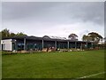
2
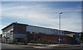
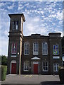
Parkside Medical Centre
Carnoustie's new medical centre, built in the west end of the town.
Image: © Gwen and James Anderson
Taken: 15 Jul 2007
0.12 miles
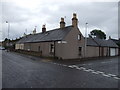
5
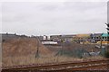
Building site, Carnoustie
View across the railway.
Image: © Richard Webb
Taken: 12 Mar 2016
0.17 miles
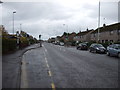
6
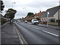
Barry Road (A930), Carnoustie
Heading east.
Image: © JThomas
Taken: 23 Oct 2013
0.20 miles
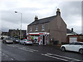
8
Anderson Street Level Crossing
This level crossing has been padlocked shut since March 2020 and it seems that Network Rail have no intention of reopening it in the near future.
Image: © Ross Murison
Taken: 25 May 2021
0.21 miles

10
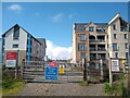
Carnoustie Early Learning and Childcare Centre
The Nursery situated in Pitskelly Park, Carnoustie which opened in the latter half of 2020.
Image: © Ross Murison
Taken: 19 May 2021
0.21 miles